|
||

|

|
|

|
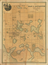
Nice example of one of the earliest obtainable maps of Florida Territory, which appeared in Anthony Finley's New American Atlas.
The map is hand colored by counties and shows only 7 counties (Escambia, Walton, Jackson, Gadsden Leon, Duval and St. John's), with no roads or settlements shown south of Lake George.
Florida was acquired by the United States Government by purchase from Spain on February 22, 1818, under the Adams-Onis Treaty, at a cost of $5 Million, however the official act for carrying the Treaty into affect was not approved by Congress until March 3, 1821. Congress officially authorized the taking of possession of East and West Florida in 1819 and the formation of a temporary government.
At the time of acquisition, East and West Florida were still separate political divisions, which were not officially merged until the establishment of Florida Territory in on March 22, 1822.
The map also includes a chart showing the comparative heights of Mountains and Cities in North America.
The Finley map is very rare on the market, this being the first time in 20 years we have offered the map.
Prior to Finley's map, only a few maps were issued focusing on Florida, including maps by William Darby (1821), Henry Schenk Tanner (1822), Fielding Lucas (1822) and Carey & Lea (1822).
Anthony Finley (1784-1836) was an American map publisher. Little is known about his life. He is presumed to have been born in Philadelphia, where he also died. A publisher, Finley was also involved in several Philadelphia civic and professional societies such as the Philadelphia Apprentices’ Library. He may have been in business as early as 1809 and his first publication dates from ca. 1811.
His first maps also date from this year, with two maps in Daniel Edward Clarke’s Travels in Various Countries of Europe, Asia, and Africa. The first atlas published by Finley appeared in 1818, the Atlas classica, or, Select maps of ancient geography, both sacred and profane, for the use of colleges and schools in the United States. He is best known for his A New General Atlas Comprising a Complete Set of Maps (1824), which was a bestseller. There were two editions in 1824, with annual editions until 1834.
Finley was part of the first generation of American publishers who produced high quality, precise maps on American soil. He was in competition with other Philadelphia publishers, for example Henry S. Tanner. Finley’s A New American Atlas Designed Principally to Illustrate the Geography of the United States of America (1826) closely mirrors Tanner’s A New American Atlas Containing Maps of the Several States of the North American Union, with similar groupings of maps; the main difference is the smaller scale of Finley’s maps. Finley printed two editions of this atlas.


![[ Florida Indians - King Outina Consulting a Sorcerer ] Outina adversus hostem exercitum ducens, de eventu Magum consulit. XII.](https://storage.googleapis.com/raremaps/img/small/97101.jpg)