|
||

|

|
|

|
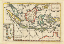
Extremely rare and important two sheet map of Asia, being the first to include significant new cartographic information for China, Korea and Japan, published by Fausto Rughesi for Vincenzo Gonzaga, the Duke of Mantua in 1597.
Rughesi's map of Asia is the first printed map to definitively show Korea (Corai) as a wide peninsula and a map of great importance for its treatment of China, including for the first time the significantly revised and updated information. The great Italian map scholar Roberto Almagia asserted that this vast leap forward reflects the fact that Rughesi had access to new and more advanced cartographic information, drawn directly from Jesuit information being transmitted back to Rome. As noted by in the on-line description of Rughesi's map of Asia in the Kraus Collection at the University of Texas:
While no definite direct source to the [set of 5 maps] can be established, it is evident that Rughesi used the most up-to-date information then available. . . . The map of Asia is cartographically the most interesting: its delineations of Korea, Japan and the Yellow Sea are far more accurate than those in the famous Linschoten map of the previous year and Rughesi is probably the first to correctly represent Korea as a peninsula.
Rughesi's maps are unknown to most bibliographers because of their excessive rarity. Only one set of the maps has survived which is now in the Vatican Library. The Vatican copies, however, are badly damaged . . .
The map is greatly improved from the maps of China and Asia by Ortelius, Mercator and De Jode, and far more advanced than Linschoten's map of China, published 1 year prior to Rughesi's map. For example, Linschoten's map of China, the first to show Korea (Ilha De Corea), treats Korea as a disembodied oval shape, with no real conception of its true relation to China. By contrast, Rughesi's map shows a very definite and accurate peninsular shape, along with significant coastal detail, including an exceptionally detailed treatment of the coastal and interior regions of China contiguous to the Korean Peninsula.
Among the most noteworthy details are the appearances of several rivers on the Korean Peninsula, which would appear to be the Han River and the Imjin River, along with Ganghwa Island. Other rivers shown include what would appear to be the Hantan River, the Taedong River and the Yalu River. At least 5 cities are also apparently located, along with several mountain ranges.
In Asia in the Making of Europe, Volume II: A Century of Wonder. Book, Donald Lach opines that the depiction of Korea as a peninsula was based upon Jesuit letters. He also notes that the depiction of Korea as an island was also included by Ignazio Danti on a map mural of Asia painted on a wall of the Vatican Library.
Rughesi's depiction of China is truly extraordinary, being by far the most detailed and comprehensive rendering of the Middle Kingdom to appear on any known printed map to date. It embraces all of late Ming Dynasty China, extending into Tibet in the interior and up to its northern limits along the Great Wall. With unprecedented detail, Rughesi provides tremendous geographical advancement, including dozens of new place names, rivers and topographical features not previously recorded by Western mapmakers. Especially significant is its delineation of the Yellow and Yangtze river basins.
Rughesi's map shows no relation to any earlier known printed map or any surviving manuscript map. It is far more refined and detailed than Ortelius' Chinae (1584), which was based on Luiz Jorge de Barbuda's manuscript map. While the portrayal of the southern coastal regions of China on Linschoten's map may surpass that featured on the present work, in terms of its general depiction of China, Rughesi's map is far superior.
It is clear that Rughesi relied upon sources not previously available to other European mapmakers. While Rughesi certainly drew on graphic interpretations of the intelligence described in the Jesuit Letters from China, 1583-4, including information from missionaries such as Matteo Ricci and Michele Ruggieri, his work clearly goes beyond the information available in these source and it is highly unlikely that such a finely detailed map was produced from these sources alone. Indeed, while it is plausible that Rughesi had access to now-lost Jesuit manuscript maps, circumstantial evidence points to another remarkable source.
At the behest of Pope Gregory XIII, between 1580 and 1585, Ignazio Danti devised a series of maps which were painted by Giovanni Antonio Vanosino as murals to adorn the Northern Wing of the Loggia della Cosmografia, located on the third floor of Raphael's Loggia at the Vatican. Unfortunately, in 1875 it was reported that all of the maps in this series had been essentially lost due to the poor climatic condidtions and decades of mishandling. While no visual records or detailed descriptions survive, an account written by Agostino Taja, who viewed the maps in 1750, suggests that they were exquisitetly rendered and based on the best sources of their time. One of these works was a map of China, "Sinese Imperium", and while no detailed description of this map survives, it is quite likely that it featured important new geographic information from the Jesuits.
Rughesi, who was well-connected and based in Rome, was almost certainly able to view this map in preparation for his own work, one may speculate that it is quite possible that Rughesi's Asia is the only surviving record of this epic cartography. Whether the source of Rughesi's milestone cartographic record of China and Korea was the now lost painting in the Loggia della Cosmografia or some other now lost source material, Rughesi's map represents one of the most important milestones in the cartography of China, which would remain the best cartographic depiction of China until the mapping done by Martino Martini in the 1640s.
The beauty of the engraving of the Rughesi's maps are remarkable and represent the highest level of artisanship at the end of the 16th Century, the so-called golden age of Italian cartography. It is also noteworthy that Rughesi's maps are the first printed map to employ an orthographic projection, a fact unknown to Nordenskjöld.
Rughesi's maps were extremely rare, even at the time of publication. For example, it is clear that the improved information for China, Korea and Japan was apparently unknown to Hondius, when he created his 1606 map of China and to Blaeu in his China Veteribus . . . of 1636. In fact, the peninsularity of Korea and the revised cartographic details in China would not be adopted by Blaeu until his publication of Martino's Novus Atlas Sinensis in 1655.
Rughesi's treatment of the Korean Peninsula, the contiguous Chinese Coastline and Northern China appears to be similar to the cartographic details later incorporated by Samuel Purchas in his Map of China published in 1625, although Purchas credited his source as being an indigenous Chinese map seized in Bantam by the English mercant Captain Saris.
Fausto Rughesi
Fausto Rughesi, a native of Montepulicano, is best known as Roman architect. His major work is the facade of the Chiesa Nuova (Santa Maria in Vallicella), of 1605. Rughesi was commissioned by Vicenzo Gonzaga, Duke of Mantua (1587-1612) to prepare a set of 5 maps maps (world and 4 continents) which he completed in 1597.
Map States
The map of Asia exists in two states, this being the only known example of the second state of the map (which was previously unrecorded). The second state can be distinguished by the removal of the dedication cartouche and coat of arms, dedicating the map to the Duke of Mantua, who had promised to pay Rughesi 200 gold crowns. Apparently, based upon surviving correspondence from 1597 and early 1598 between Annibale Chiepo and Rughesi (recorded by Fiorini in his article on Rughesi's world map), it is known that the Duke failed to pay the second half of his promissed commission to Rughesi, almost certainly the cause for Rughesi's masking out the dedication and coats of arms of his patron, in order to offer the map at his own expense.
Masking a portion of a plate involved placing a blank piece of paper over a part of the printing plate, in order to prevent that part of the plate from striking the paper and leaving a printed impression. The paper was placed on the plate after the plate was inked, resulting in the 2 blank ovals present in the map of Asia shown here.
In 2008, a copy of the World map by Rughesi was offered for sale in 2008 by Shapero Rare Books of London for £180,000. In 1969, three maps of Rughesi, depicting America, Asia and Africa appeared in the sale catalog of HP Kraus of New York, Monumenta Cartographica, offered for sale at the then princely sum of $6,000.
rarità dei secoli XVI e XVII esistenti nella Biblioteca Apostolica Vaticana, pp.69-74, XXII; M. Fiorini, Bollettino della Società Geografica Italiana, Il mappamondo di Fausto Rughesi, pp. 956/972; Betz, Maps of Africa, 36; Shirley, Mappi
![[Hubei, China] Province De Hou-Quang](https://storage.googleapis.com/raremaps/img/small/95546.jpg)