|
||

|

|
|

|
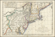
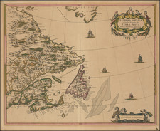
Nice example of the Bowles & Carver map of New England, based upon Braddock Mead's 4-sheet map of 1755.
Originally printed by John Bowles circa 1765, the map is one of the earliest maps to include the names of the townships within New England, a number of which are not yet named. Other interesting annotations include a note in New Hampshire referncing "Wilderness Lands of the Crown not yet appropriated," and observations concerning "French Encroachments" in the region.
The map identifies a number of early forts on the Hudson River, just south of Lake Champlain. Fort Hunter and a reference to William Johnson appear north of Albany. with a road running west of the Hudson River north to Fort William Henry.
This is the sixth state of the map, which can be distinguished by the imprint of Bowles & Carver. Over the 30 year life of the map, the map was continuously revised, both geographically and a constantly changing title. According to Stevens & Tree, the states are as follows:
- 1st state: John Bowles imprint
- 2nd state: Carrington Bowles imprint-1st Jany. 1771.
- 3rd state: New Title: Bowles's Map of the Seat of War in New England; Boston & Environs inset added.
- 4th state: New Title: Bowles's New Pocket Map of the Most Inhabited Part of New England.
- 5th state: Vermont is added, with a note "This States extends Northward to the 45th degree of Latitude.
- 6th state: New Title: Bowles's New One-Sheet Map of New England, comprehending the Provinces . . .; Bowles & Carver imprint