|
||

|

|
|

|
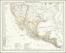
Important early (quite possibly the first) Texas railroad map, showing the railroad lines in the vicinity of Houston and Galveston, Texas, within a few years of the completion of the first railroad lines in Texas.
The present map is remarkably detailed, showing the completed portions of the Galveston, Houston & Henderson Railroad in Blue, those parts of the line under construction in pink and the planned lines with a heavy black and white pattern. The map also shows the completed portions of the Buffalo, Bayou, Brazos & Colorado Railroad and the Houston Central Railroad. The explanation key also indicates the prospective elevations for the line and other technical details. The map itself is remarkably technical in nature, showing distances, proposed train stations and other information.
The map is remarkable not only as an early artifact of the Galveston, Houston & Henderson Railroad, but for its depiction of the earliest lines constructed in Texas. As noted below, as of the printing of this map, the lines depicted constituted virtually all of the active railroad lines in Texas, and is unquestionably the only large format map to illustrate these lines prior to the Civil War.
Based upon the progress of construction of the line and the (erroneous) naming of the Houston Central Railroad, the map almost certainly dates to 1857 or 1858, well before the line reached Houston.
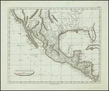
The Galveston, Houston, & Henderson Railroad was raising money in London and Paris beginning in 1853-1854, in order to finance the development of the railroad. This is quite possibly the earliest printed map to focus on the railroad lines in and around Houston and Galveston and perhaps the earliest railroad map for any part of Texas. The first railroad map of Texas listed in Modelski is Modelski 551, Map of Texas showing the Sabine and Galveston Bay Railroad, 1859. The earliest in Day is the 1861 Map of the Buffalobayou (Day 135).
The history of Railroads in Texas begins in 1836, with the Charter of the Texas Rail Road, Navigation, and Banking Company by the First Congress of the Republic of Texas, which failed by 1836, having failed to begin construction. There were 3 other attempts during the Republic period to start a railroad. Of these 3, only 1, the Harrisburg and Brazos, later renamed the Harrisburg Railroad and Trading Company, made any progress toward construction (grading 2 miles and undertaking other preparations, before its failure).
The first line to construct rail was the Buffalo Bayou, Brazos and Colorado Railway Company, charted on February 11, 1850. Workd commenced in 1851 and the first locomoative arrived in 1852. A 25 mile line from Harrisburg to Stafford's Point was opened in September 1853, becoming the first Texas Railroad and the second line west of the Mississippi.
The second line to construct rail was orginally chartered as the Galveston and Red River Railway in 1848. Construction on the line began in January 1853 and a 25 miles segment from Houston to Cyprus was completed by July 1856. Shortly thereafter, the line was changed to the Houston and Texas Central Railway.
Before the end of the 1856, the City of Houston completed a 7 mile line, connecting to a junction with the Buffalo Bayou, Brazos and Colorado Railway line to the south.
The Galveston, Houston and Henderson Railroad Company was chartered on February 7, 1853, to build from Galveston through Houston to Henderson. The early incorporators included W. C. Lacy, T. P. Anderson, R. A. Harris, and William M. Tuck. The company was an important carrier and, for a number of years, Galveston's only rail connection with the Texas railroad system centering at Houston. Although supported in Galveston and Houston, much of the early financing was provided by investors in Holland and France.
Construction of the "Old Reliable Short Line," as the road was later called, began at Virginia Point on the mainland opposite Galveston Island in 1854. However, the first rail was not laid until 1857 and in 1859 the company finally reached Houston, where it terminated at the corner of Main and McKinney. Only two curves, one on either side of Harrisburg, were required between Virginia Point and Houston. A trestle across Galveston Bay, built from the proceeds of a Galveston County bond issue, was finished in 1860, thus completing the rail line between the two cities.
The original company was sold out in 1860, and a new Galveston, Houston and Henderson was organized under the original charter. During the Civil War the railroad remained active, handling the traffic to and from the blockade runners reaching Galveston. The tracks and the Galveston Bay bridge were used by Gen. John B. Magruder in his recapture of Galveston on January 1, 1863. In 1867 the bondholders of the original company forced the railroad into receivership.
The Rosenberg Library has a map titled " Texas Etas Unis D'Amerique Trace du Chemin de Fer de Galveston a Houston et Henderson, " also lithographed in Paris and quite possibly from the same source. We note that the dimensions given for the Rosenberg map are about 16 x 15.5 inches.
We note also a map which we sold to David Rumsey, showing all of the state of Texas: www.davidrumsey.com/luna/servlet/detail/RUMSEY~8~1~201~20062:Texas-Of-The-United-States-Of-Ameri
![[ Texas - Dallas to El Paso ] Flight Chart- Dallas Fort Worth to El Paso, U.S.A.](https://storage.googleapis.com/raremaps/img/small/98371.jpg)
![(Republic of Texas Land Grants with Maps - Coahuila y Tejas) [Manuscript land grant documents issued by Radford Berry, alcalde of Nacogdoches, to John Adams and others, with manuscript plat maps by Arthur Hendrie and George Aldrich]](https://storage.googleapis.com/raremaps/img/small/88920.jpg)
![[ Indian Territory / North Texas / Arkansas ] General Topographical Map. Sheet XXIV. Plate CLIX](https://storage.googleapis.com/raremaps/img/small/95113.jpg)
![(Dallas, Texas) USAF Target Complex Mosaic-Series 25 [Sheets 0 - 4]](https://storage.googleapis.com/raremaps/img/small/87119.jpg)