The item illustrated and described below is sold, but we
have another example in stock. To view the example which
is currently being offered for sale, click the
"View Details" button below.
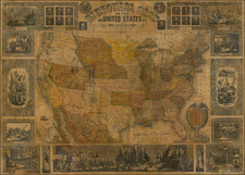
1863 Adolphe Hippolyte Dufour
$ 345.00


|
||

|

|
|

|
Stock# 32781
Description
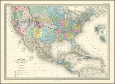
Attractive large format map of the US & Mexico on the eve of the Civil War.
Includes marvelous ephemeral western territorial border. California is oddly shaped, extending only to the Sierras. Massive Utah Territory, with New Mexico Territory to the East. Washington Terr. Extends to the Rocky Mountains. Nebraska Territory extends form the Rockies to the Missouri. Texas is oddly configured and the French colony is highlighted in Blue. Pre-Gadsden border w/ Mexico.
![Mexican Painting. 3776 Codex Vaticanus page 74. Aglio 3rd Vol. called the Little Vatican MS. [on sheet with] Quetzalcoatl Crucified Codex Borgianus...](https://storage.googleapis.com/raremaps/img/small/102318.jpg)
![[German Northern Pacific Promotional Tract] Die Nordliche Pacific Eisenbahn; Ihre Route, hulfsquellen, fortschritte & Gefchafte. der neue Nord-Westen und seine grosse Verkehrs-Strasse.](https://storage.googleapis.com/raremaps/img/small/83777.jpg)