|
||

|

|
|

|
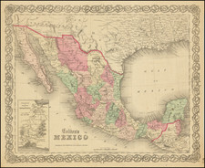
Fine example of the rare 1913 US War Department Reproduction of Molina's impressive map of Mexico, originally published by the Secretaria de Formento) (Mexican Ministry of Commerce), for the use of the Ministry of Education (Secretario de Ramo).
Olegario Molina, a former governor of the Yucatan, was Secretary of Development from 1907 to 1911, and a powerful figure under President Porfirio Diaz.
The map is one of the best for Mexico of the early 20th century. It was so highly regarded that in 1913 it was the only contemporary map of Mexico reproduced by the War College for the archives of the U. S. War Department.
The following information describes the differences between the map. The Bulletin of the American Geographic Society, Vol 46. No. 6 (1914), pp. 433-36 notes:
Finally the Comision has published a general map of Mexico on the scale of 1:2,000,000 entitled "Carta General de la Republica Mexicana formada en la Secretaria de Fomento por disposicion del Secretario del Ramo, Lie. Olegario Molina, 1910," whose scale might indicate some relation to the proposed sheet map on the same scale, although it is drawn and published as a unit. Relief is in red-brown shading, drainage in blue, towns whose positions have been astronomically determined in red, others in black, roads in yellow brown and railroads in black.
Similarly, the Royal Geographical Society Bulletin of 1911 notes that Molina's map is:
A useful general map of Mexico in four sheets. Relief is lightly indicated by brown shading, railways and roads are clearly shown, and a table of the positions in latitude and longitude of the principal places is given on the south-east sheet.
![[Arizona below New Mexico] Mexique d'apres le grand Atlas Dresse Par A.H. Dufour Grave par ch Dyonet Pubie par A. Le Chevalier . . . 1863](https://storage.googleapis.com/raremaps/img/small/64395.jpg)
![(Mexican-Aztec Artwork) [Original pencil tracing of Aztec Calendar]](https://storage.googleapis.com/raremaps/img/small/102327.jpg)
![Amer. Sep. No. 70. Partie Du Mexique [Acapulco]](https://storage.googleapis.com/raremaps/img/small/96401.jpg)