|
||

|

|
|

|
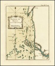
Detailed plan of Pondichery, from De Fer's Atlas Curieux.
The map shows the town plan, neighboring fortifications, roads, neighboring villages and the lower Pondichery River. Includes a key locating essential place names.
The ancient history of Pondicherry is associated with Saint Agasthya, the revered sage of the south. Excavations near Pondicherry have revealed the existence of a Roman settlement some 2000 years ago. It was also the site of many battles between the British, Dutch and French and was also the capital of French India.
Puducherry (or Pondicherry) was a part of the Pallava kingdom of Kanchipuram in the fourth century AD. During the next few centuries Pondicherry was continued to be under the control of several dynasties of the south. In the tenth century A.D. the Cholas of Thanjavur ruled the region for over 300 years but later on it was replaced by the Pandya Kingdom. Till 1638, Pondicherry came under various rulers like the Muslim rulers of the North; the Vijayanagar Empire and then the Sultan of Bijapur came to rule over Gingee.
The French East India Company set up its trading centre at Puducherry in 1673. This outpost eventually became the chief French settlement in India. The Dutch and British trading companies also wanted trade with India. Wars raged between these European countries and spilled over into the Indian subcontinent. The Dutch captured Pondicherry in 1693 but returned it to France by the Treaty of Ryswick in 1699.
During the Anglo-French wars (1742-1763), Pondicherry changed hands frequently. On January 16, 1761, the British captured Puducherry from the French, but the Treaty of Paris (1763) returned the city to the French. It was taken again by the British in 1793 amid the Wars of the French Revolution, but once again returned to France in 1814. When the British gained control of the whole of India in the late 1850s, they allowed the French to retain their settlements in the country. Pondicherry, Mahe, Yanam, Karaikal and Chandernagar remained a part of French India until 1954.
Nicholas de Fer (1646-1720) was the son of a map seller, Antoine de Fer, and grew to be one of the most well-known mapmakers in France in the seventeenth century. He was apprenticed at twelve years old to Louis Spirinx, an engraver. When his father died in 1673, Nicholas helped his mother run the business until 1687, when he became the sole proprietor.
His earliest known work is a map of the Canal of Languedoc in 1669, while some of his earliest engravings are in the revised edition of Methode pour Apprendre Facilement la Geographie (1685). In 1697, he published his first world atlas. Perhaps his most famous map is his wall map of America, published in 1698, with its celebrated beaver scene (engraved by Hendrick van Loon, designed by Nicolas Guerard). After his death in 1720, the business passed to his sons-in-law, Guillaume Danet and Jacques-Francois Benard.
![(India) Decima Asie Tabula [Tenth Map of Asia]](https://storage.googleapis.com/raremaps/img/small/101340.jpg)
![India Forest Lands Under Government Control [with:] India Agriculture [and:] India Annual Rainfall & Temperature [and:] India Minerals](https://storage.googleapis.com/raremaps/img/small/101419.jpg)
![[Tiruchirappalli] 1763 Plan de Trichenapaly](https://storage.googleapis.com/raremaps/img/small/58955.jpg)