


|
||

|

|
|

|
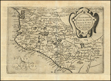
A Cartographic landmark -- The Only Spanish Map of Texas & the West published in the 18th Century and the first map to identify Texas as a geographic region.
Fine example of the rare Spanish edition of Mexican-born cleric and scientist José Antonio de Alzate y Ramírez's map of Mexico, published in Madrid, most likely by Spain's first great 18th Century mapmaker, Tomas Lopez.
Alzate's map was the first printed map to locate Texas as a geographic region (Provincia de los Texas) and the only Spanish map of the Texas and the Southwest published during the 18th century. As such, is a cartographic landmark of the highest importance. While there were a number of Spanish political and military tours of inspection into the region and several extensive reports on the conditions in the region, none of these reports nor their accompanying manuscript maps were published until Don Jose Antonio de Alzate y Ramirez published this map of New Spain, drawn from official sources and his own manuscript maps.
Alzate y Ramirez is considered one of the pioneers of scientific journalism, who embraced the ideas of the Enlightenment and devoted his life to the study of all branches of science. When the Mexican National Academy of Science was formed in 1884, it was named the Alzate Society.
As noted by map historian Woodbury Lowery:
The map is interesting, because being made principally in the year 1767, it depicts to us the state of knowledge, which the Spaniards had acquired of Upper-California and the Colorado River, immediately before the commencement of the modern explorations of these regions by the Franciscan Missionaries (since 1769) and by the great Spanish Northwest navigations (since 1774). The darkness was really great, as our map shows . . .
Alzate's map shows much of Spanish America with a condensed view of California north of San Diego, the location of Indian tribes, and Louisiana, 4 decades prior to the territorial purchase of Thomas Jefferson. As noted by Robert Sherwood in The Cartography of Alexander von Humboldt:
As a prominent scientist, Alzate was given access to official information available in Mexico. Such information was almost certainly unavailable to the map trade at the time. Alzate based his maps on official reports and sketches of the expeditions of the early eighteenth century.
Alzate's map is the only large format map of Texas, Upper California and Mexico published by a Spaniard in the 18th Century. As noted by the Texas State Historical Association's on-line article, the Spanish Mapping of Texas, Alzate y Ramirez drew heavily upon the map of Francisco Álvarez Barreiro:
Among the more notable efforts in Texas and Borderlands cartography is that of Francisco Álvarez Barreiro, a military engineer with the inspection expedition of Pedro de Rivera y Villalón (1724-28). Álvarez Barreiro drew a series of six maps depicting the northern and western provinces of New Spain that were visited by the Rivera inspection. This group constitutes "the first detailed mapping of the region from actual observations by a trained mapmaker." Texas is included on an overall map, "Plano corográfico é hidrográphico," which reflects Álvarez's visit to the province with Rivera in 1727 and his personal exploration from La Bahía to the southeastern corner of Texas. The map, owned by the Hispanic Society of America since 1907, was brought to scholarly attention only in 1992. A remarkable achievement for its day, it is especially noteworthy for its depiction of the upper Texas coast, which had scarcely been explored previously. Leaning heavily on the Álvarez Barreiro map, José Antonio de Alzate y Ramírez published his Nuevo Mapa Geográfico de la América Septentrional (Madrid, 1768). Alzate repeats some of Álvarez Barreiro's inaccuracies, which had become known through more recent exploration. . . .
The map is quite probably drawn directly from a manuscript map by Alzate y Ramirez, entitled Nuevo Mapa Geografico De La America Septentrional española, divida en obispados y provincias, dated 1767, which is referenced by Daniela Bleichmar in Science in the Spanish and Portugese Empires, 1500-1800. The printed map also includes a list of the Bishopricks and Provinces, as noted in the title of the manuscript. By 1772, Alzate y Ramirez had produced a second manuscript map entitled Plano geografico de la mayor parte de la America septentrional española. The failure to include the 1772 date or the names of Don Carlos Siguenza and the engineer "Balleyro" (both identified in the manuscript map), would tend to suggest that this map is based solely on the 1767 map. In later years, these maps would come to the attention of Alexandre von Humboldt who commented that Alzate had embraced too many things all at once and displayed more zeal than accuracy.
The rivers of Texas are distorted, shown as flowing due south, or even slightly southwest, instead of southeast. Alzate's treatment of the Rio Grande is relatively accurate for the time (although Martin & Martin suggest otherwise), and omits the Pecos River. The western branch of the Rio Grande is called to "ro de Chama". Near that river is a settlement that still exists, named "Chama," located just a few miles below the Colorado border. It thus appears that Alzate's map extends north into southern Colorado, near the headwaters of the Rio Grande.
Further east, a grand Rio de Medina appears to have been confused with the absent Pecos at its head, and with the Nueces at its mouth. The Nueces, in its turn, with its branches the Hondo and the Frio, shows up as a minor tributary of the Rio Grande. Although exaggerated, the Guadalupe is shown, along with its tributary the San Marcos, which carries the name given it in 1719 by the Marques de Aguayo, "Los Innocentes." The river Alzare labeled the San Marcos was probably the Colorado, and the confusion over the names of the Colorado and Brazos he demonstrated by assigning both names to the Brazos. Alzate shows the Trinity River in a way that would have crossed the basins of the Red River and the Arkansas River.
The missions around San Antonio, as well as those at La Bahia, San Saba, and Orcoquisac, and those in East Texas are shown. Adaes, east of the Sabine, is properly showed as the capital, prior to its relocation in 1773 to San Antonio, at the recommendation of the Marques de Rubi.
Alzate y Ramirez's map is the earliest map to locate the Province of Texas ("Provincia de los Texas"). The map shows the route of French naval officer Pierre-Marie-Francois Pagés through Louisiana, Texas, and Mexico, along with Native American tribes residing in the area.
While the map may, as Humboldt noted, suffer from some serious inaccuracies by modern standards, it is rightly considered a cartographic landmark. As noted by Jackson in Shooting the Sun,
What we have from Alzate, even with its many faults, is magnificent in its own way. He drew maps that are beautiful expressions of cartographic art, poised on the verge of scientific knowledge that would have taken them out of the decorative realm. This knowledge was slow in coming, and Alzate was fully aware that his productions were far from being correct. More observations were needed-especially in the northern provinces and especially concerning longitude-but Alzate pressed ahead with what he knew. That he did not "know it all" (no one else did either) is hardly a measure of his success. If we mortals waited to do something until no chance for error existed, we would have few records indeed of our search for truth. Alzate left us his contribution so that others might, by standing on his shoulders, see farther than he had been able to do. For this, he takes his place among the other giants of his era and deservedly ranks among the brightest minds of colonial Mexico.
The Two Editions -- Spanish and French
There are apparently 2 editions of the Alzate map, each known in two states. They are described as follows:
Spanish-Geografico Edition: The edition referred to herein as the Spanish-Geografico edition of the map has the following characteristics:
- Engraved and printed with 4 separate copper plates (unlike the French edition, which is a single plate)
- The word Geografico in the title is spelled with an "f", rather than a "ph" (the French edition is spelled Geographico.
- No box surrounding the title
- Includes much more boldly engraved mountains.
- Pacific Ocean spelled "Pacifico" (not Pazifico, as in French edition).
- No note referring to Mr. Chappe's observations in California regarding the transit of Venus, first published in 1772 (only appears in the French edition).
- The note referencing Vizcayno's voyage is properly phrased in Spanish "Esta Costa se ha dispuesto por el unico reconocimiento se ha hecho de ella en el Ano de 1602 por Sebastian Viscayno," whereas the French edition misspells "dispuesto" (dispuerto).
- The note referencing the Moqui Villages "Pueblos rebeldes de Moquis. . . 1680" is correctly spelled, whereas the French edition misspells "rebeldes" (rebelles), referencing the Pueblo Indian Revolt of 1680.
- This edition references both names for Cabo de S. Lucas (o Cabo de Ballenas). The reference to Ballenas (whales) is omitted from the French edition.
- Numerous other spelling errors are present in the French edition, but not the Spanish edition.
There are two states of the Spanish-Geographico edition. One includes the imprint "Se hallera en Madrid, calle de Atocha, frente la casa de los Gremios." The other lacks the "...casa de los Gremios" imprint.
This Spanish-Geografico edition was almost certainly published in Madrid, if in fact either of the two editions were published outside of Paris. It is also likely the map was published surreptitously. Dissemination of printed cartographic information regarding the colonial possessions in the New World was rare in Spain in this time period, although Spanish mapmakers such as Tomas Lopez were being trained in Paris by the likes of D'Anville during the 1750s, there was still very little map publication in the following decade involving Spain's colonial interests. While Spanish Enlightenment was moving toward open publication, the maps printed in Spain in the 1760s which do not include the name of a mapmaker were generally published without privilege and likely done surreptitiously. This may also explain the rarity of the "casa de los Gremios" imprint. The "calle de Atocha, frente a la Casa de los Gremios" imprint and variants were employed by Tomas Lopez with some regularity between 1780 and 1810.
The French-Geographico edition: The edition referred to herein as the French-Geographico edition was published in Paris and can be distinguished by the following characteristics
- Engraved and printed using a single plate
- spelling of the word "Geographico" rather than "Geografico" in the Spanish edition.
- Box surrounding the title
- Less boldly engraved mountains.
- Pacific Ocean spelled Pazifico. In Spanish edition, it is spelled Pacifico.
- Note referring to Mr. Chappe's observations in California regarding the transit of Venus, first published in 1772 (only appears in the French edition).
- The note referencing Vizcayno's voyage is properly phrased in Spanish "Esta Costa se ha dispuesto por el unico reconocimiento se ha hecho de ella en el Ano de 1602 por Sebastian Viscayno," whereas the French edition misspells "dispuesto" (dispuerto).
- The note referencing the Moqui Villages "Pueblos rebeldes de Moquis. . . 1680" is correctly spelled, whereas the French edition misspells "rebeldes" (rebelles), referencing the Pueblo Indian Revolt of 1680.
- This edition references both names for Cabo de S. Lucas only. The reference to Cabo de Ballenas (whales) is omitted from the French edition.
- Numerous other spelling errors are present in the French edition, but not the Spanish edition.
The French edition was published in two states, one of which includes the Dezauche imprint (contained in 2 text lines at the bottom center, below the neatline). The second state shows that it was "Publie sous le Privilege de l'Academie Rle. des Sciences de Paris," (Published under the Privilege of the Royal Academy of Sciences in Paris) but without the Dezauche imprint. There do not appear to be any differences between the two French-Geographico states of the map other than the Dezauche imprint below the bottom neatline.
Primacy of the Spanish-Geografico Edition
While the question of where and when the maps were published has been open to debate for some years, this writer believes that it is relatively clear that the Spanish-Geografico edition was the first edition to be published. The most compelling reasons for this conclusion are:
- The spelling errors in the text of the map strongly suggest that the French map is a copy of the Spanish map, with transcription errors noted above.
- The Transit of Venus observations were made in 1769 and first reported in 1772, and is only included in the French edition.
- The Title to both maps are in Spanish and largely identical, but for spelling errors in the French edition.
- Dezauche, publisher of one of the French editions, only became active in about 1780.
One of the strongest pieces of evidence of the primacy of the Spanish edition can be found by its failure to include the note regarding Mr. Chappe's expedition to California to observe the transit of Venus. In the French-Geographico edition, the map includes the following note above the observed positions of 3 cities in Mexico:
Depuis l'envoy de cette carte, le voyage de Mr. Chappe 'a la Californie a procure des corrections dans la position de differens endroits qu'il es interessant d'indiquer ici.
( Since this map was received, the trip of Mr. Chappe to California provides corrections in the different places described below which are interesting to mention here.)
There is no similar text added to the Spanish-Geografico edition.
One curious fact that must be reconciled is that one of the two states of the Spanish edition bears the imprint "Se hallara en Madrid, calle de Atocha, frente la casa de los Gremios." This imprint would suggest a post-1780 publication date by Tomas Lopez, the only mapmaker known to use this address. As the Dezauche state of the French edition of the map was almost certainly published after 1780, there is good reason to believe that this map was not published in or about 1768 and that all 4 states of the map referenced above were in fact published after 1780.
On balance, it seems that the most likely scenario was that the Alzate map was first engraved after 1770 by Tomas Lopez. Lopez likely did so surreptitiously, as there is no attribution or Spanish royal privilege for the map. The reference to the privilege granted by the Royal Academy of Sciences in Paris was quite likely a ruse, in order to avoid blatantly flaunting the lack of Spanish royal privilege. Lopez, as Spain's most important mapmaker of the period, would have had the necessary access to the Alzate manuscript maps and in fact his son would later print the Barreiro map after 1800. Lopez is known to have published a number of Alzate's manuscript maps.
Whether Lopez willingly shared the information with his French colleagues is not apparent, although it is clear that the map was distributed on a very limited basis. Lopez certainly had the necessary connections, but there seems to be no evidence that there was either communication or collaboration. The fact that neither the BNF or the British Library have copies of the Spanish edition suggests that it was printed in very limited numbers.
Woodbury Lowery identified both Spanish states of the map and dated them 1768. He similarly identifies the French-Dezauche edition as 1768.
All states of the map are very rare on the market, this being the first example of the Spanish map we have offered for sale and seen on the market in over 20 years. Dorothy Sloan offered for sale the edition of the Spanish map with the Gremios imprint in 2013. www.dsloan.com/Auctions/A23/item-map-alzate-nuevo_mapa-1768.html.
The only other example offered at auction which we could locate in the past 50 years was the Streeter copy in 1966.
We offered an example of the French edition without the Dezauche imprint for sale in 2012. /gallery/detail/30212
OCLC locates the following examples:
Spanish edition (Gremios): 1 copy. Yale.
Spanish edition (no imprint): Likely mis-catalogued as French edition (University of Michigan, Clements)
French edition (Dezauche): University of Michigan (Clements); Library of Virginia; John Carter Brown (Streeter copy)
French edition (no imprint): BNF; British Library.
Lowery states that the Library of Congress holds the French edition with the Dezauche imprint.
José Antonio de Alzate y Ramírez (1737 – 1799 ) was a Mexican priest, scientist, historian, cartographer and journalist.
Alzate y Ramirez was born in Ozumba and studied in the Colegio de San Ildefonso in Mexico City, graduating as a bachelor in theology in 1756.
Alzate y Ramirez was also a corresponding member of the French and Spanish academies of science, and one of the earliest trustworthy observers of Mexican meteorology. He attained a high reputation as a zoologist and botanist, and his researches led the way for modern exploration of Mexican antiquities.
He published the Gaceta de Literatura, and an essay titled La limite des niéges perpetuelles en Volcan Popocatepetl. He conducted several scientific experiments, and wrote numerous articles that were published in science journals. Inaugurated in 1768, his Diario literario de Méjico was suspended after only three months. He later created, in 1788, the Gaceta de Literatura, that was published until 1795.
In his lifetime, he wrote over thirty treatises on various subjects. Among other works, he wrote Observaciones meteorológicas (1769), Observación del paso de Venus por el disco del Sol (1770), Modelo y descripción de los hornos de Almadén, notes, additions and maps for the Historia Antigua de México, written by Francisco Javier Clavijero, and a Mapa de la América del Norte.
He also prepared a landmark map of New Spain and, in 1772, he published work that showed that the well-known psychedelic effects of pipiltzintzintli were due to natural causes and not the work of the devil.
In his honor, the Sociedad Científica Antonio Alzate was created in 1884. In 1935, this society became the National Academy of Sciences.
![[Arizona below New Mexico] Mexique d'apres le grand Atlas Dresse Par A.H. Dufour Grave par ch Dyonet Pubie par A. Le Chevalier . . . 1863](https://storage.googleapis.com/raremaps/img/small/64395.jpg)
![[ Colorado Atlas -- Presentation Copy ] Geological and Geographical Atlas of Colorado and Portions of Adjacent Territory](https://storage.googleapis.com/raremaps/img/small/101702.jpg)