![[ Spain & Portugal ] Tabula II Europae (Title on Verso) By Lorenz Fries](https://storage.googleapis.com/raremaps/img/small/103197.jpg)


|
||

|

|
|

|
Early 16th Century Map of the Iberian Peninsula
The present map is a reduced-size version of Martin Waldseemüller's 1513 depiction of the Iberian Peninsula and the Balearic Islands, first published in Strasbourg by Johannes Gruninger in 1522. While the map is dran drietly from Waldseemuller's map of 1513, its foundations lie in the ancient work of Claudius Ptolemy, a Roman scholar of Greek origin, whose invaluable contributions to cartography continue to inspire and influence centuries later.
The map consists of a stunning array of geographical features, towns, and cities, meticulously positioned. The Iberian Peninsula, a landmass distinctive for its irregular, almost rectangular shape, juts into the surrounding water bodies, with the Atlantic Ocean to its west and north, and the Mediterranean Sea to its east and south.
The Balearic Islands lie off the eastern coast in the Mare Balearicum.
Ptolemy's influence on this map is unmistakable. As a geographer and mathematician in 2nd-century Alexandria, he developed a world map based on the knowledge and accounts accumulated over the centuries by the Romans, Greeks, and Persians. His primary sources were travelers' tales, itinerant traders' accounts, and military expeditions. Ptolemy sought to create a comprehensive, accurate picture of the known world by compiling, comparing, and sometimes correcting these diverse sources.
For the Iberian Peninsula, Ptolemy relied on a variety of accounts. The peninsula was a region well-known to the Romans; it had been a province of the Roman Empire since the 3rd century BC, after the conclusion of the Second Punic War. The region's towns, cities, and prominent features were widely recorded in Roman accounts, and Ptolemy was able to incorporate this data into his map with a high degree of accuracy.
However, Ptolemy's map was not without its errors. For instance, he significantly underestimated the breadth of the peninsula, resulting in a condensed representation. Nonetheless, his work was a significant achievement for its time, and it served as the basis for Waldseemüller's more accurate map in the 16th century.
Lorenz (Laurent) Fries was born in Alsace in about 1490. He studied medicine, apparently spending time at the universities of Pavia, Piacenza, Montpellier and Vienna. After completing his education, Fries worked as a physician in several places, before settling in Strassburg, in about 1519. While n Strassburg, Fries met the Strasbourg printer and publisher Johann Grüninger, an associate of the St. Die group of scholars formed by, among others, Walter Lud, Martin Ringmann and Martin Waldseemuller.
From 1520 to 1525, Fries worked with Gruninger as a cartographic editor, exploiting the corpus of material that Waldseemuller had created. Fries' first venture into mapmaking was in 1520, when he executed a reduction of Martin Waldseemuller's wall-map of the World, published in 1507. While it would appear that Fries was the editor of the map, credit is actually given in the title to Peter Apian. The map, Tipus Orbis Universalis Iuxta Ptolomei Cosmographi Traditionem Et America Vespucii Aliorque Lustrationes A Petro Apiano Leysnico Elucubrat. An.o Dni MDXX, was issued in Caius Julius Solinus' Enarrationes, edited by Camers, and published in Vienna in 1520.
Fries next project was a new edition of the Geographia of Claudius Ptolemy, which was published by Johann Koberger in 1522. Fries evidently edited the maps, in most cases simply producing a reduction of the equivalent map from Waldseemuller's 1513 edition of the Geographie Opus Novissima, printed by Johann Schott. Fries also prepare three new maps for the Geographie: maps of South-East Asia and the East Indies, China and the World, but the geography of these derives from Waldseemuller's world map of 1507.
The 1522 edition of Fries work is very rare, suggesting that the work was not commercially successful. In 1525, an improved edition was issued, with a re-edit of the text by Wilibald Pirkheimer, from the notes of Johannes Regiomontanus. After Grüninger's death in 1531, the business was continued by his son Christoph, who seems to have sold the materials for the Ptolemy to two Lyon publishers, the brothers Melchior and Gaspar Trechsel, who published a joint edition in 1535, before Gaspar Trechsel published an edition, in his own right, in 1541.
Lorenz (Laurent) Fries (ca. 1485-1532) was born in Mulhouse, Alsace. He studied medicine, apparently spending time at the universities of Pavia, Piacenza, Montpellier and Vienna. After completing his education, Fries worked as a physician in several places before settling in Strasbourg in about 1519. While in Strasbourg, Fries met the Strasbourg printer and publisher Johann Grüninger, an associate of the St. Dié group of scholars formed by, among others, Walter Lud, Matthias Ringmann and Martin Waldseemüller.
From 1520 to 1525, Fries worked with Grüninger as a cartographic editor, exploiting the corpus of material that Waldseemüller had created. Fries' first venture into mapmaking was in 1520, when he executed a reduction of Martin Waldseemüller's wall map of the world, first published in 1507. While it would appear that Fries was the editor of the map, credit is actually given in the title to Peter Apian. The map, Tipus Orbis Universalis Iuxta Ptolomei Cosmographi Traditionem Et Americ Vespucii Aliorque Lustrationes A Petro Apiano Leysnico Elucubrat. An.o Dni MDXX, was issued in Caius Julius Solinus' Enarrationes, edited by Camers, and published in Vienna in 1520.
Fries’ next project was a new edition of the Geographia of Claudius Ptolemy, which was published by Johann Grüninger in 1522. Fries evidently edited the maps, in most cases simply producing a reduction of the equivalent map from Waldseemüller's 1513 edition of the Geographie Opus Novissima, printed by Johann Schott. Fries also prepared three new maps for the Geographia, of Southeast Asia and the East Indies, China, and the world, but the geography of these derives from Waldseemüller's world map of 1507.
The 1522 edition of Fries' work is very rare, suggesting that the work was not commercially successful. In 1525, an improved edition was issued, with a re-edit of the text by Willibald Pirkheimer, from the notes of Regiomontanus (Johannes Müller von Königsberg).
After Grüninger's death in ca. 1531, the business was continued by his son Christoph, who seems to have sold the materials for the Ptolemy to two Lyon publishers, the brothers Melchior and Gaspar Trechsel, who published a joint edition in 1535, before Gaspar Trechsel published an edition in his own right in 1541.
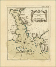
![[Portugal] Pascaarte vande Zeecusten van Portugal tusschen de Barlenges en de C. de S. Vincente geleghen, vertoonende nae't leven de ware geleghentheijt vande vermaerde Riviere van Lisbona . . .](https://storage.googleapis.com/raremaps/img/small/52231.jpg)
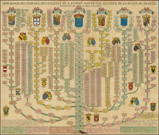
![[T erceira ] Circuito da Ilha Terceira, dividido em 8 Districtos Militares, forca de cada um, e os lugares accessi veis, os quars sao indicados com o signal, *' assim as pecas com a letra p](https://storage.googleapis.com/raremaps/img/small/77790.jpg)