
This item has been sold, but you can enter your email address to be notified if another example becomes available.


|
||

|

|
|

|
Stock# 30774
Description
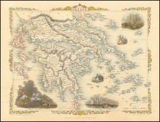
A detailed map of the Greek Islands and contiguous islands and regions, from Harris' Navigantium, first published in 1744.
Includes large cartouche and compass rose.
Emanuel Bowen Biography
Emanuel Bowen (1694?-1767) was a British engraver and print seller. He was most well-known for his atlases and county maps. Although he died in poverty, he was widely acknowledged for his expertise and was appointed as mapmaker to both George II of England and Louis XV of France. His business was carried on by his son, Thomas Bowen. He also trained many apprentices, two of whom became prominent mapmakers, Thomas Kitchin and Thomas Jeffreys.
![The Severn or Channel of Bristol [with a chart of the Irish Sea.]](https://storage.googleapis.com/raremaps/img/small/47485.jpg)
![Les Estats de la Couronne d'Arragon en Espagne ou sont l'Arragon Royaume, la Catalogne Princip[au]té, la Valence Royaume, et les Isles de Maiorque... 1653](https://storage.googleapis.com/raremaps/img/small/80239.jpg)