|
||

|

|
|

|
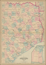
Nice example of Karl Baedeker's map of Texas, published in 1849, and surmounted with a large Lone Star flag.
Texas is still shown in its Republic configuration, incorporating Santa Fe, Taos and all of New Mexico east of the Rio Grande, as well as a portion of Colorado south of the Arkansas River, a border which Texas would claim until the Compromise of 1850.
Baedeker's map was prepared for German emigrants, who were then actively flowing into Texas. The two active German colonies ( Deutsche Colonie des Mainzer Vereins and Franxos) appear in yellow in the south central part of the state. Some counties are outlined in red and there are areas shaded in color. Major cities, roads, bodies of water, and geographic features are marked (with relief shown by hachures). The names and locations of some Native American Indian tribes are also marked in western and northern portions of the state. There are two insets: "Plan von Neu-Brunfels und Comalstadt" (lower left corner) and "Plan von Castroville" (lower right corner), these being amont the earliest printed plans of each of the towns.
The map occasionally appears in Bracht's guidebook, Texas im Jahre 1848.