


|
||

|

|
|

|
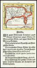
Scarce 2 sheet map of the Florida, Texas, the Gulf Coast, Central America, the Yucatan and Caribbean, published by Buache in 1740.
Based upon Popple's 20 sheet map, Buache provides a remarkably detailed image of the Gulf of Mexico, including the routes of the Spanish ships and the currents of the ocean in the Caribbean well before the "discovery" of the Gulf Stream.
Though Buache had drawn a manuscript map of the Gulf region before Popple's map was published, he updated his rendering to take into account the improved information. While the focus of the map is on the navigational information, with soundings, shoals, currents, and so forth, Buache includes much information of the interior of South America, Central America, and what the southern part of present-day United States from Texas to Georgia.
With its large size and typical French attention to detail, this is one of the best maps of the region from the first half of the eighteenth century.
Philippe Buache (1700-1773) was one of the most famous French geographers of the eighteenth century. Buache was married to the daughter of the eminent Guillaume Delisle and worked with his father-in-law, carrying on the business after Guillaume died. Buache gained the title geographe du roi in 1729 and was elected to the Academie des Sciences in the same year. Buache was a pioneering theoretical geographer, especially as regards contour lines and watersheds. He is best known for his works such as Considérations géographiques et physiques sur les découvertes nouvelles dans la grande mer (Paris, 1754).
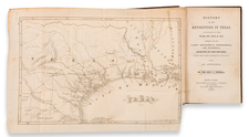
![(Texas Maps & Alamo View) Memoir Descriptive of the March of a Division of the United States Army, Under the Command of Brigadier General John E. Wool from San Antonio De Bexar, in Texas to Saltillo, in Mexico [caption title:] Report ... Communicating a Map Showing the Operations of the Army of the United States in Texas and the Adjacent Mexican States on the Rio Grande [with:] Map Showing the Line of March of the Centre Division, Army of Mexico, under the Command of Brigr. Genl. John E. Wool, from San Antonio de Bexar, Texas to Saltillo, Mexico [and:] Map Showing the Route of the Arkansas Regiment from Shreveport, La. to San Antonio de Bexar Texas](https://storage.googleapis.com/raremaps/img/small/100805.jpg)
![[St. Augustine, Florida] Pagus Hispanorum in Florida](https://storage.googleapis.com/raremaps/img/small/92794.jpg)