


|
||

|

|
|

|
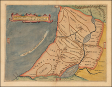
A striking example of Waldseemuller's modern map of the Holy Land.
This work was based on the manuscript maps of Sanuto and Vesconte of c.1320, which were updated by Nicholaus Germanus in 1482 to include more cities and textual information.
In its greatest departure from the Ptolemaic model, the map shows the land of Palestine divided among the 12 tribes of Judaea. The map is oriented to the southeast as indicated by the lines of latitude in the top margin. The map is very similar to the modern Holy Land map first issued in the 1482 Ulm edition of Ptolemy's Geographia, but includes additional decorative embellishments, including the large ship.
The first modern atlas, prepared by Martin Waldseemuller using the translation of Mathias Ringmann. This is one of the most important editions of Ptolemy, containing many new regional maps. Twenty new maps based on contemporary knowledge were included by Waldseemuller, in addition to the traditional twenty-seven Ptolemaic maps derived from the 1482 Ulm edition.
Martin Waldseemuller and his associate Mathias Ringmann, prepared this edition of Ptolemy, partly at the expense of Duke Rene of Lorraine. It was brought to completion by Jacobus Eszler and Georgius Ubelin. The atlas contains the first map in an atlas entirely devoted to America (Tabula terre nove), often called the "Admiral's map" after Columbus. The map of Lotharingia (the first map of the Duchy of Lorrain), printed in black, red and olive, is one the earliest examples of color-printing. This edition was reprinted in 1520 using the same woodcut blocks.
Martin Waldseemüller (c. 1475-1520) was a sixteenth-century cosmographer best known for his 1507 world map in twelve sheets, the earliest surviving map to include the name “America.” He was an influential mapmaker during his time whose work affected many of his contemporaries and successors. Waldseemüller was born near Freiburg, in what is now southwestern Germany. His family moved to Freiburg proper when he was young and he attended university in the city beginning in 1490.
Waldseemüller gathered information about the New World discoveries and geography from St.-Dié des Vosges in Lorraine, where he was a professor of cosmography under the patronage of René II, Duke of Lorraine. He was a member of an intellectual circle who produced work from the St.-Dié Press. However, the press failed when the Duke died, and Waldseemüller moved to Strasbourg.
He is best known for the 1507 map and another world projection, the Carta Marina published in 1516. He also published an edition of Ptolemy in 1513, in collaboration with Johann Schott, a friend from Freiburg and St.-Dié. Besides his innovative use of the toponym “America”, Waldseemüller was the first to create such a large printed world map, the author of the earliest known printed globe gores, the first to create a published collection of modern maps, and one of the first to create maps from ground measurements. He was knowledgeable in surveying methods and designed a quadrant and other instruments. He returned to St.-Dié late in life as canon, although he continued to return to Strasbourg for work and for carnival. He died in St.-Dié in 1520.
Waldseemuller is generally credited with having named the continent of America, based upon the then current belief that Amerigo Vespucci had been the first modern explorer to reach the continent of America in 1497, during the first of four expeditions to America which were then credited to Vespucci between 1497 and 1504. The report which described the 1497 expedition is now generally believed to be a forgery. Later in his career, Waldseemüller elected not to use the toponym for the continents, preferring to leave them unnamed. However, the name had been taken up by his contemporaries, in large part due to the influential nature of Waldseemüller’s earlier works.
![[Tribe of Judah] Tribus Iuda id est, pars illa Terra Sanctae quam in ingressu Tribus Iuda confecuta fuit](https://storage.googleapis.com/raremaps/img/small/82548.jpg)
