


|
||

|

|
|

|
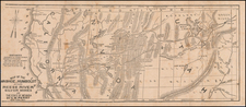
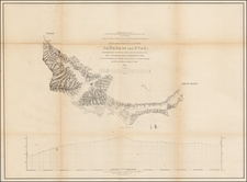
Rare early map of the Nevada Territory mining Districts, with a specimen cover page for the Commonwealth Mining Company.
The map receives nearly a full page write up in Wheat's Mapping of the Transmississippi West (#1129). Wheat identifies the source of the map as being from a pamphlet entitled The Mountain Queen Silver Mining Company . . . (New York, 1865), which is apparently known in only one example (New York Public Library). Wheat states:
. . . The main business of the map is to locate mining districts in Nevada; and a great many are shown. Special emphasis is given to Austin, since the Mountain Queen properties were half a mile south of the at city. In California, the only mining areas are noted (except "Sutter's Mill Coloma First Discovery of Gold") are "Cosmopolitan Copper Mine" at the head of the north fork of the Feather River, and some "Union and Table Mt. Copper Mines" north of the Calaveras River, between Sacramento and Stockton. The old emigrant road is shown around the north end of Great Salt Lake, down the Humboldt, and as far west as the Valley of the Mud Lakes east of Honey Lake. Railroads, actual or projected, are noted in the Sacramento Valley; and from Auburn the "Central Pacific Railroad" finds its way across the Sierra to the Truckee, thence over to and up the Humboldt, and on to Utah Lake by a route south of Snow Water Lake. . . . The "United States Mail Route," the old Simpson route, is heralded, "Proposed Railroad."
The map also seems to be one of the earliest printed map sources for a number of early Mining District names. See Joseph V. Tingley, Mining Districts of Nevada, Nevada Bureau of Mines and Geology Report 47 (1998). After De Groot's map, this seems to be one of the best early sources for locating the names of the earliest mining districts. . "
The work is one of the earliest mining reports on Nevada Territory. The report contains accounts of the towns, mines and settlements, together with many pages of extracts from local papers. Eberstadt Catalog 111-404 (1938) states:
One of the earliest accounts of the new mineral region, the great rush, the settlements, town building, developments, etc. The work is in large part from the pen of the correspondent of the San Francisco News Letter, whose series of articles is reprinted entire, and from the accounts in the infant press of the territory, notably the Reese River Reveille and the Virginia Daily Union.
The Month at Goodspeed's Vol. 39:5, #35 (1968 -- priced at $150.00) states:
Wagner-Camp 409A, which notes that the "Map of the Washoe, Humboldt & Reese River Silver Mines in ... Nevada by E. W. Perry, New York, 1865 "is the same as that in the report of A. Blatchly et al, on "The Silver Districts of Nevada." N. Y., 1865 (Wagner-Camp 409), but that "the text differs entirely from the Blatchly pamphlet, & does not mention Blatchly or give his report." Among the reports of the mines contained here are Prof. Silliman's (as printed in the Reese River Reveille), a series of letters to the San Francisco News Letter & Mining Journal, extracts from a "log-book" describing the founding of Virginia City from Horace Greeley's articles for the New York Tribune, etc."
The Blatchly Silver Districts of Nevada was apparently also published by Van Nostrand and consists of 37 pp and a folding map. Streeter (who did not own a copy of the Bryant work), notes "The pamphlet does give most interesting details of the development of the great silver mines around Austin, Nevada." (Streeter, 2341, 1968--auction sale price $100).
The present pamphlet is unrecorded. We suspect that the name of the company may have been changed before incorporation, as we have located no record of this company's formation.
![Mexique par Th. Duvotenay…1842 [Republic of Texas]](https://storage.googleapis.com/raremaps/img/small/93713.jpg)
![[Mission San Luis Rey] Vue de La Mission de Saint Louis Roi De France](https://storage.googleapis.com/raremaps/img/small/71720.jpg)