


|
||

|

|
|

|
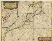
Fine example of Bowen's map of Georgia.
Bowen's map of Georgia is one of the most highly sought after of all maps of Georgia. Published in John Harris' N avigantium atque Itinerantium Bibliotheca, or Complete Collection of Voyages and Travels, first published in London in 1705, the map of Georgia first appeared in the 1744-48 and 1764 editions, when a new Chapter was added, giving a history of Georgia.
The map covers the region from Charleston to the Mississippi River. Cumming notes that it is one of the best large format maps of the region during the period, showing coastal settlements in South Carolina, the Indian Tribes friendly or hostile to the English, and the chief trading paths of the period. Indian territories are shown by fine dotted lines. The Georgia roads and settlements are particularly complete. Excellent detail along the Flint River.
Emanuel Bowen (1694?-1767) was a British engraver and print seller. He was most well-known for his atlases and county maps. Although he died in poverty, he was widely acknowledged for his expertise and was appointed as mapmaker to both George II of England and Louis XV of France. His business was carried on by his son, Thomas Bowen. He also trained many apprentices, two of whom became prominent mapmakers, Thomas Kitchin and Thomas Jeffreys.


![Charte von Den Vereinigten Staaten von Nord-America nebst Louisiana . . . 1805 [Rare 1st State of Gussefeld's Louisiana Purchase Map]](https://storage.googleapis.com/raremaps/img/small/63496.jpg)
![A Topographical Description of Such Parts of North America as are Contained in the (Annexed) Map of Middle British Colonies, &c. in North America [with map:] A Map of the Middle British Colonies in North America. First published by Mr. Lewis Evans ... in 1755; and since Corrected and Improved, as also extended with the addition of New England, and bordering parts of Canada; from actual surveys ... by T. Pownall](https://storage.googleapis.com/raremaps/img/small/100077.jpg)