|
||

|

|
|

|
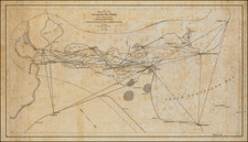
Striking full color example of Homann's map of the Course of the Mississipp River, based upon the reports of Hennepin, who explored the upper Mississippi and Great Lakes regions as a Jesuit Missionary in the late 1600s.
The map follows the work of De L'Isle in his seminal map covering the same region. The Mississippi is oddly misprojected, with the Ohio and several other rivers splitting to the east and tracking near a vignette showing Indians hunting long horn buffalo. The western rivers, including the Missouri, are equally inaccurate. The map shows a number of explorer routes throughout the Southwest and Louisiana and annotations regarding various regions. Many Indian Tribes and early forts named. Florida is an archipelago. Nice detail in Texas.
One of the most interesting and decorative regional maps of America from the period.
Johann Baptist Homann (1663-1724) was a mapmaker who founded the famous Homann Heirs publishing company. He lived his entire life in Bavaria, particularly in Nuremberg. Initially, Johann trained to become a priest before converting to Protestantism and working as a notary.
In 1702, Johann founded a publishing house that specialized in engravings. The firm flourished, becoming the leading map publisher in Germany and an important entity in the European map market. In 1715, Johann was named Imperial Geographer to the Holy Roman Empire by Charles VI and made a member of the Prussian Academy of Sciences. Most importantly for his business, his reputation and contacts gained him imperial printing privileges which protected his publications and recommended him to customers. Johann is best known for this Grosser Atlas ueber die ganze Welt, or the Grand Atlas of the World, published in 1716.
After Johann died in 1724, the business passed to his son, Christoph (1703-1730). Upon Christoph’s early death, the company passed to subsequent heirs, with the name of the company changing to Homann Erben, or Homann Heirs. The firm continued in business until 1848.

![[ Ohio - Seven Ranges ] Plat of the Seven Ranges of Townships being Part of the Territory of the United States N.W. of the River Ohio which by a late act of Congress are directed to be sold . . . 1785](https://storage.googleapis.com/raremaps/img/small/82394.jpg)