


|
||

|

|
|

|
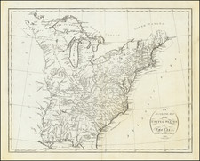
Fine original color example of Purcell's map of the Southern States (and Midwest), which includes an early reference to the New State of Franklin in Western Carolina and Eastern Tennessee.
This map first appeared in Jeddidiah Morse's American Georgraphy and in some copies of the August 1788 edition of the American Magazine. Later examples were issued by Stockdale in London.
On this example, Georgia is colored curiously, as it should cut short South Carolina to the west of the Cherokee lands, possibly a colorists error.
Shows the boundaries between the United States and Spanish Dominions, lines delimiting Indian Nations, Towns, Roads, Indian Villages and host of other early details, including counties, Indian Trade paths, the Seven Ranges, Ekanfanoka Swamp (Okenfenokee), Port Vincient (Vincennes), The Ohio Company, New Jersey Company and Illinois Company Lands are shown, as are the Donation Lands of the Commonwealth of Virginia.
The Illinois, Indiana & New Jersey Company land areas appear, as do Army Land, Ohio Company, along with numerous counties in Virginia. Notes regarding Col. Syms Land, the donation grants and Gen. Clark's Grant are also shown. The Spanish Dominions and Louisiana appear east of the Mississippi River, and the region north of Virginia is called the New States, although predating the deliniation of Ohio, Indiana and Illinois. Many other interesting details.
![[Eastern Sheet -- Ohio] Post Road Map of the States of Ohio and Indiana with Adjacent Parts of Pennsylvania Michigan Illinois Kentucky and West Virginia Showing Post Offices With The Intermediate Distances and Mail Routes In Operation On the !st of February 1885 . . .](https://storage.googleapis.com/raremaps/img/small/44153.jpg)
![(Three Days at Gettysburg) Map of the Battlefield of Gettysburg July 1st, 2nd, 3rd 1863. . . [Three Maps]](https://storage.googleapis.com/raremaps/img/small/101769.jpg)
![[ Ohio - Seven Ranges ] Plat of the Seven Ranges of Townships being Part of the Territory of the United States N.W. of the River Ohio which by a late act of Congress are directed to be sold . . . 1785](https://storage.googleapis.com/raremaps/img/small/82394.jpg)