


|
||

|

|
|

|
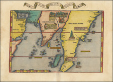
Nice full color example of the 1541 edition of Fries map of India and Southeast Asia, focusing on Southeast Asia, India, and Sri Lanka and the Indian Ocean.
Fries map is a reduced size version of Waldeseemuller's 1513 map, the earliest modern map to focus on the region. All prior maps of the region were prepared based upon the work of Claudius Ptolemy.
Based largely upon the Ruysch world map of 1507, Sri Lanka and the Indian subcontinent are relatively correct in their sizes. This map is among the earliest documents recording the Portugese explorations into the Indian Ocean, and is of primary importance in the mapping of the India and Southeast Asia.
Various decorative embellishments are shown within the map, showing indigenous peoples and customs. Extends from Saudi Arabia to the Malay Peninsula, centered on India.
Lorenz (Laurent) Fries (ca. 1485-1532) was born in Mulhouse, Alsace. He studied medicine, apparently spending time at the universities of Pavia, Piacenza, Montpellier and Vienna. After completing his education, Fries worked as a physician in several places before settling in Strasbourg in about 1519. While in Strasbourg, Fries met the Strasbourg printer and publisher Johann Grüninger, an associate of the St. Dié group of scholars formed by, among others, Walter Lud, Matthias Ringmann and Martin Waldseemüller.
From 1520 to 1525, Fries worked with Grüninger as a cartographic editor, exploiting the corpus of material that Waldseemüller had created. Fries' first venture into mapmaking was in 1520, when he executed a reduction of Martin Waldseemüller's wall map of the world, first published in 1507. While it would appear that Fries was the editor of the map, credit is actually given in the title to Peter Apian. The map, Tipus Orbis Universalis Iuxta Ptolomei Cosmographi Traditionem Et Americ Vespucii Aliorque Lustrationes A Petro Apiano Leysnico Elucubrat. An.o Dni MDXX, was issued in Caius Julius Solinus' Enarrationes, edited by Camers, and published in Vienna in 1520.
Fries’ next project was a new edition of the Geographia of Claudius Ptolemy, which was published by Johann Grüninger in 1522. Fries evidently edited the maps, in most cases simply producing a reduction of the equivalent map from Waldseemüller's 1513 edition of the Geographie Opus Novissima, printed by Johann Schott. Fries also prepared three new maps for the Geographia, of Southeast Asia and the East Indies, China, and the world, but the geography of these derives from Waldseemüller's world map of 1507.
The 1522 edition of Fries' work is very rare, suggesting that the work was not commercially successful. In 1525, an improved edition was issued, with a re-edit of the text by Willibald Pirkheimer, from the notes of Regiomontanus (Johannes Müller von Königsberg).
After Grüninger's death in ca. 1531, the business was continued by his son Christoph, who seems to have sold the materials for the Ptolemy to two Lyon publishers, the brothers Melchior and Gaspar Trechsel, who published a joint edition in 1535, before Gaspar Trechsel published an edition in his own right in 1541.
![[Fort Gingee & The Great Mountain of Gingee]](https://storage.googleapis.com/raremaps/img/small/58792.jpg)
![(Disputed Territories - Pakistan) Pakistan (West) [and] Pakistan (Ost), 1966](https://storage.googleapis.com/raremaps/img/small/80936.jpg)
![[Mumbai] Plan De Bombay et ses Environs](https://storage.googleapis.com/raremaps/img/small/75975.jpg)
![[ Indian Ocean - Sailing to Batavia ] Route Exacte De Gamron a Batavia et de Batavia a Gamron](https://storage.googleapis.com/raremaps/img/small/44380.jpg)