![[Jerusalem's Two Hills] Hierosolyma, Clarissima Totius Orientis Civitas Iudaee Metropolis . . . By Georg Braun & Frans Hogenberg](https://storage.googleapis.com/raremaps/img/small/74099.jpg)


|
||

|

|
|

|
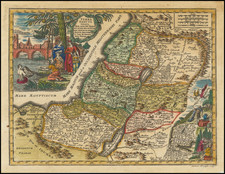
Striking early pair of plans of Jerusalem, from Braun & Hogenberg's
Civitates Orbis Terrarum, the most famous and influential book of town plans published in the 16th Century.
Fascinating engraving containing two aerial views of Jerusalem. At the left, Jerusalem is illustrated based upon illustrations and accounts of Biblical Jerusalem as it was at the beginning of the first century BC. At the right, a modern view of the City, as it appeared in the 16th Century. Each is accompanied by legends listing important structures and places that are keyed to the plans. In the lower right is a vignette of Moses receiving the Commandments along with Aaron, whose garments and accouterments are listed in the table to the right.
Georg Braun (1541-1622) was born and died in Cologne. His primary vocation was as Catholic cleric; he spent thirty-seven years as canon and dean at the church St. Maria ad Gradus, in Cologne. Braun was the chief editor of the Civitates orbis terrarum, the greatest book of town views ever published. His job entailed hiring artists, acquiring source material for the maps and views, and writing the text. In this role, he was assisted by Abraham Ortelius. Braun lived into his 80s, and he was the only member of the original team to witness the publication of the sixth volume in 1617.
Frans Hogenberg (ca. 1540-ca. 1590) was a Flemish and German engraver and mapmaker who also painted. He was born in Mechelen, south of Antwerp, the son of wood engraver and etcher Nicolas Hogenberg. Together with his father, brother (Remigius), uncle, and cousins, Frans was one member of a prominent artistic family in the Netherlands.
During the 1550s, Frans worked in Antwerp with the famous mapmaker Abraham Ortelius. There, he engraved the maps for Ortelius’ groundbreaking first atlas, published in Antwerp in 1570, along with Johannes van Deotecum and Ambrosius and Ferdinand Arsenius. It is suspected he engraved the title page as well. Later, Ortelius supported Hogenberg with information for a different project, the Civitates orbis terrarium (edited by Georg Braun, engraved by Hogenberg, published in six volumes, Cologne, 1572-1617). Hogenberg engraved the majority of the work’s 546 prospects and views.
It is possible that Frans spent some time in England while fleeing from religious persecution, but he was living and working in Cologne by 1580. That is the city where he died around 1590. In addition to his maps, he is known for his historical allegories and portraits. His brother, Remigius, also went on to some fame as an engraver, and he died around the same time as his brother.

![Terra Sancta sive Palaestina exhibens non solum Regna Vetera Iuda et Israel in Suas XII Tribus Distincta . . . 1759 [The Holy Land, or Palestine, displaying not only the ancient kingdoms of Judah and Israel divided into their Twelve Tribes... 1759]](https://storage.googleapis.com/raremaps/img/small/90182.jpg)
![[ Gifted To Cecil B. De Mille by Elmer Bernstein ] (Mortier Bible) Histoire du Vieux et du Nouveau Testament Enrichie de plus de quatre cens Figures En Taille-Douce, &c. [2 vols in 1]](https://storage.googleapis.com/raremaps/img/small/96625.jpg)