|
||

|

|
|

|
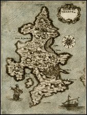
Fine example of Sylvanus' map of Greece, one of the earliest obtainable maps of the region and the first printed in two colors.
Sylvanus' map of Greece is one of the earliest obtainable maps of the region and one of the first to incorporate modern information. While it is based upon the Geography of Claudius Ptolemy, it differs from the earlier maps of printed editions of Ptolemy (Bologna 1477, Rome 1478, Ulm 1482, Berlingheri 1482 and Rome 1507), presenting some hints of modern information not present in the earlier maps. As noted by Ashley Baynton Williams
The most unusual of the editions of Ptolemy, was that published by Jacobus Pentius de Leucho in Venice in 1511, edited by Bernardus Sylvanus. Sylvanus, realizing the geography [of Ptolemy] was out-dated, attempted to update the maps by inserting more modern information, often from contemporary manuscript sources, over the Ptolemaic material, creating an unusual effect. An innovative feature is that the maps, which are printed from woodblocks, are printed in two colors, red and black, with the principal names in red.
Bernardus Sylvanus (Bernardo Silvano) was born around 1465 in Eboli, a small agricultural town near Salerno in southern Italy. He began studying Ptolemy around 1490, when he was living in Naples. At this time he ran a print shop or studio, producing maps and codices. It was here that he produced his first edition of Ptolemy’s Geographia in 1490, which he dedicated to Andrea Matteo Acquaviva, the third Duke of Atri. For this edition Sylvanus used coordinates and text from Jacopo d’Angelo’s translation, and copied the maps from a Roman printed edition of either 1478 or 1490 (both printed from the same plates). Sylvanus’ 1511 Venice edition of the Geographia built on his prior work, but was groundbreaking in several regards. It was the only edition to add modern updates directly into Ptolemy’s maps, the only edition at the time to print maps on both sides of the leaf, the first edition printed in two colors, and the first Italian edition to use woodblocks. Nothing is known of Sylvanus’ life after the publication of this edition.
![[Greece] Tabula Europae X](https://storage.googleapis.com/raremaps/img/small/86695.jpg)
![[ Bosnia ] Izlozba Drazavni Osiguravajua Zavod Direkcija za nr Bosnui Hercegovinu (Exhibition of The Insurance Institute Directorate of Bosnia Herzagovina)](https://storage.googleapis.com/raremaps/img/small/50706.jpg)