|
||

|

|
|

|
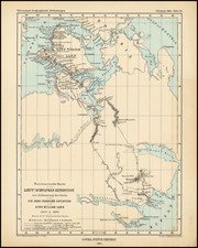
Fine Eighteenth-Century Map of the Arctic
Elegant and finely-wrought map of “Northeast and Northwest of the Pole,” published by Amsterdam-based French scholar and mapmaker Jean Frédéric Bernard.
The map encompasses the polar region from Tartary to modern-day Nunavut to “Parts Unknown,” with four fine compass roses and a simple yet attractive title cartouche.
The most eye-drawing feature of this particularly well-preserved example of Bernard’s map is “The Northern Pole,” located slightly off of center in the upper half of the map and surrounded by four compass roses that allow the viewer to keep track of north despite the map’s 360° scope. The Arctic Circle is prominently represented. In the bottom left-hand corner, a simple legend, rendered in English—unlike the title, which is in French—explains the mapmaker’s abbreviations.
The emergent nature of the information with which the mapmaker was working is represented by the incomplete outlines of the polar landmasses. Though some sections of the map, for example Iceland, are extremely well detailed, other sections are left blank. For the map’s eighteenth-century viewers, much of this map would have represented regions at the very edge or beyond the frontier of European knowledge.
This map was derived from Moses Pitt’s 1680 map, though it omits Pitt’s decorative whaling scenes. Bernard, who included the map in his work, Recueil de Voyages du Nord, preserves Pitt’s division of Greenland into three islands. Interestingly, the mapmaker also reproduces Pitt’s English language place names, details, and legend, with a few exceptional French place names. These include notes on the movements of European polar explorers: “Here Hudson wintered, a[nn]o 1611,” “Here Cap Iames wintered 1631.” He has even copied the little tent where, “the Hollanders wintered here ano 1569.”
The first edition of Recueil de Voyages du Nord was published in three volumes in Amsterdam in 1717. This example is from the expanded edition, published from 1725 to 1738.
Bernard’s map helped his readers make sense of the voyages described in his multivolume work. It profoundly shaped European perceptions of the frozen North in the generations following the pioneering voyages of Hudson, James, and Barentz.