|
||

|

|
|

|
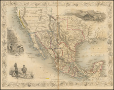
Exceedingly rare first edition of Tanner's map, one of the most important maps in 19th Century American History.
In this rare first edition, first state of Tanner's map (dated 1825), the map properly illustrates the boundary between the United States and Mexico. In the second state (dated 1826), the boundary is erroneously moved to the north in what is then shown as New Mexico. It is this erroneous boundary line between the two countries that is copied first by White Gallaher & White in 1828 ( Mapa de los Estados Unidos de Méjico . . .). Thereafter, in 1846, after John Disturnell acquires the White Gallaher & White plate and re-issues the map in 1846 and 1847 without changes to this boundary line, the erroneous Tanner / White Gallaher & White / Disturnell boundary becomes the official boundary between the United States and Mexico, until the error is discovered by the Boundary Survey Commissioners, which in turn necessitates, among other factors, the 1853 Gadsden Purchase.
Wheat noted that in the first edition of the map "the southern bounday of New Mexico seems to follow Humboldt, but in 1826 Tanner alterd that boundary west of El Paso, bring it further north." It was this 1826 issue of the map which became the source for the White Gallaher and White map of 1828, which in turn became the source for Disturnell's celebrated "Mapa de los Estados Unidos de Mejico, first published in 1846," creating the erroneous boundary in the Treaty of Guadalupe Hidalgo.
Tanner based the present map on the work of Alexander von Humboldt, Don Juan Pedro Walker, Zebulon M. Pike, William Darby, Bernardo de Orta, J.F. de Lángara y Huarte, and other sources. Tanner's map was often copied, both in the U.S. and abroad.
Tanner's maps of Mexico were a primary sources on Mexico and the emerging western territories of the United States for three decades. For instance, Tanner's 1834 map was one of the few sources to include Stephen F. Austin's maps and (Tanner also published Austin's maps). As Wheat notes, the map was probably rushed into production to take advantage of the great interest in news of the Mexican-American War.
In all, a nice example of one of the most important maps in American history.
![[ Texas Pictorial Map Artwork ]](https://storage.googleapis.com/raremaps/img/small/65261.jpg)