|
||

|

|
|

|
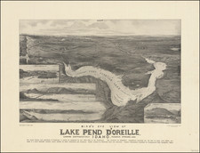
Detailed mining claim map for Buffalo Hump, Idaho, compiled by Hill and Tillson in Grangeville, Idaho and corected by L.W. Myer, Mining Engineer, in Lewiston, Idaho.
The map is oriented with east at the top and shows dozens of mining claims, along with the following geological and man made locations:
- Buffalo Hump
- Wagon Road to Elk City
- Wagon Road to Grangerville
- Crystal Lake
- Deer Lake
- Deer Creek
- Sheep Creek
- Headwaters of Twenty Mile Creek
As referenced in The Geology and Ore Deposits of the Buffalo Hump District, published in Annals of the New York Academy of Science (1927), the surveys conducted by Hill and Tillson were among the most authoritative observations taken at the outset of the 1898 Gold Rush.
Buffalo Hump Mining District is located in the Nez Perce National Forrest.
Buffalo Hump, the most prominent of the peaks of the Clearwater Mountains, rises in the center of a triangle formed by the three mining towns of Warren, Elk City and Florence. These mining camps were formed following the Gold Rush of 1862, which in the 1860's produced something over $100,000,000 in placer gold.
James H. Hawley stated:
Of the thousands who came into the new camp of Florence during the summer of 1862, nearly all stopped for a short time at least. The limited area of place ground, however, in that vicinity, soon became apparent and prospecting parties started in all directions. As usual in all mining camps the unfounded reports of rich discoveries soon became circulated among those remaining in the camp, and it was early in the summer of 1862 that a rumor became current there that rich mines had been discovered at the base of the mountain known as Buffalo Hump, a well known mountain, situated about forty miles northeast of Florence, and to the new El Dorado went practically all of those who had come into the new section; they packed their scant amount of provisions and blankets on their backs and started for the new El Dorado, but only disappointments awaited them there, as they soon ascertained. There was no placer gold and the gold-bearing ledges cropping out in many places were of a low grade and could not be profitably worked at that time.
Some years later, Buffalo Hump mines began to prosper in 1898. Charles F. Robbins and Bert Rigley Young discovered and staked the Big Buffalo and Merrimac claims on August 7, 1898. This touched off the Buffalo Hump boom and led to renewed mining activity throughout the area. There were three towns recognized in the Buffalo Hump area: Hump Town, where only some building foundations and a pile of whiskey and beer bottles remain; Frog Town, lower down in the basin; and Concord, where a few buildings were standing in 1954.
From "Illustrated History of North Idaho,"
No one had any idea of the enthusiasm that the Buffalo Hump strike has arroused. It is all and even more than the locators claimed for it. The assays run to phenomenal values and none of the returns have been low. The strike itself is one of the most phenomenal geological freaks ever discovered. It consists of a huge vein of ore thrown up on the face of the plain and for five miles one can ride along beside it on horseback. In its course the vein runs straight through the Salmon River.
For two weeks past men have been flocking from all directions to the camp. At night the camp fires resemble those of an army; for miles around they leap heavenward. More than two hundred prospectors were living in tents along the vein when I left Grangeville. Florence and the other camps are almost depopulated; men threw up good jobs to get to the strike; you meet them on foot, huge packs on their backs; on horseback, two men on a horse . . . all with but one thought -- to stake out a claim before all are gone.
For years trained and veteran prospectors camped beside it, and climbed over and around to get into the renowned diggings in Boise Basin, in the Florence district, in the northern counties, into the Seven Devils country and to dozens of other localities long since forgotten.
The present map would seem to have been drawn relatively early in the boom period, as its crude nature and the means by which it was prepared suggests that that its compiler and maker could only rely upon a free hand drawing of the topographical features upon which to plot the various mining claims shown.
This map is apparently unrecorded. In fact we were unable to locate any other 19th Century (or early 20th Century) maps focusing on the details of the Buffalo Hump region and none relating to the 1898 Gold Rush, with the exception of 2 photocopies of 1899 maps held by the Idaho Historical Society.
![Map of Oregon, Washington and Part of Idaho [First Appearance Of Idaho Territory, including western Montana and Western Wyoming]](https://storage.googleapis.com/raremaps/img/small/94211.jpg)