|
||

|

|
|

|
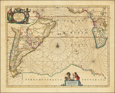
Marvelous coastal map of Africa, showing the region between the Mosambique Channel and Madagascar, with large insets of Borbon and Isle de France.
Includes ad ecorative title cartouche. From Zatta's monumental Altante Novissimo, one of the last great decorative atlases of the 18th Century.
Antonio Zatta (fl. 1757-1797) was a prominent Italian editor, cartographer, and publisher. Little is known about his life beyond his many surviving published works. It is possible that he was born as early as 1722 and lived as late as 1804. He lived in Venice and his work flourished between 1757 and 1797. He is best known for his atlas, Atlante Novissimo (1779-1785), and for his prolific output of prints and books that were both precisely made and aesthetically pleasing. Zatta clearly had a large network from which to draw information; this is how he was able to publish the first glimpse of the islands visited by Captain Cook in the Atlante Novissimo. Zatta also published books of plays and architecture.
![[Simon's Town / False Bay, South Africa] Seamons Bay in the Bay of False](https://storage.googleapis.com/raremaps/img/small/87276.jpg)
![[Orange Free State, Transvaal, Natal and Part of the Cape Colony] Africa do Sul Folha 1 | Estado Livre d'Orange, Natal, e regiones que limitam com o Transvaal e Colonia do Cabo](https://storage.googleapis.com/raremaps/img/small/90963.jpg)
![[Southern Africa] Kaart van het Zuidelykste Gedeelte van Afrika of het Land der Hottentotten](https://storage.googleapis.com/raremaps/img/small/89739.jpg)