|
||

|

|
|

|
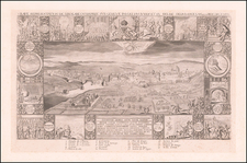
Fine example of Braun & Hogenberg's set of 13 views of Swiss towns, first issued in 1572.
The towns illustrated are Schwyz, Unterwalden, Zug, Glarus, Basel, Zurich, Bern, Lucerne, Uri, Fribourg, Solothurn, Schaffhausen and Appenzell.
Between 1291 and 1512, the 13 original Swiss cantons slowly forged a single alliance, the Old Swiss Confederation, which lasted until 1798. The 13 cantons are illustrated across double page in relatively small views, accompanied by the year in which they joined the Confederation. According to Swiss national legend, the three cantons of Schwyz, Unterwalden and Uri were the first do pledge their mutual allegiance in what is known as the "Rutli oath", taken in August 1291 on the Rutli meadow on the shores of Lake Lucerne. Braun's sources date the birth of the Confederation to 9 December 1315, when the original three cantons signed the Pact of Brunnen after the victorious battle of Morgarten against the Habsburgs.
Eleven of the 13 views derive from a single set of sources: the woodcuts from the Schweytzer Chronick of Johannes Stumpff, 1548. Each of those rectangular illustrations in a horizontal format takes up half a folio page: here they have been considerably reduced in scale and, most noticeably, the proportions have been changed. There are no reliably verifiable sources for Zug and Unterwalden; consequently Zug is erroneously shown by a river instead of the lake at Zug and Unterwalden as a mountain village without distinguishing features. (Taschen)
Georg Braun (1541-1622) was born and died in Cologne. His primary vocation was as Catholic cleric; he spent thirty-seven years as canon and dean at the church St. Maria ad Gradus, in Cologne. Braun was the chief editor of the Civitates orbis terrarum, the greatest book of town views ever published. His job entailed hiring artists, acquiring source material for the maps and views, and writing the text. In this role, he was assisted by Abraham Ortelius. Braun lived into his 80s, and he was the only member of the original team to witness the publication of the sixth volume in 1617.
Frans Hogenberg (ca. 1540-ca. 1590) was a Flemish and German engraver and mapmaker who also painted. He was born in Mechelen, south of Antwerp, the son of wood engraver and etcher Nicolas Hogenberg. Together with his father, brother (Remigius), uncle, and cousins, Frans was one member of a prominent artistic family in the Netherlands.
During the 1550s, Frans worked in Antwerp with the famous mapmaker Abraham Ortelius. There, he engraved the maps for Ortelius’ groundbreaking first atlas, published in Antwerp in 1570, along with Johannes van Deotecum and Ambrosius and Ferdinand Arsenius. It is suspected he engraved the title page as well. Later, Ortelius supported Hogenberg with information for a different project, the Civitates orbis terrarium (edited by Georg Braun, engraved by Hogenberg, published in six volumes, Cologne, 1572-1617). Hogenberg engraved the majority of the work’s 546 prospects and views.
It is possible that Frans spent some time in England while fleeing from religious persecution, but he was living and working in Cologne by 1580. That is the city where he died around 1590. In addition to his maps, he is known for his historical allegories and portraits. His brother, Remigius, also went on to some fame as an engraver, and he died around the same time as his brother.
![[ Valais Canton ] Das ober Wallisserlandt | Wallisser landt wie du sichst. . .](https://storage.googleapis.com/raremaps/img/small/95847.jpg)
![[Valais Canton] Das under Wallisserlandt](https://storage.googleapis.com/raremaps/img/small/95848.jpg)