|
||

|

|
|

|
Detailed map showing the proposed expansion plan for the Sacatela Storm Drain project, which ultimately led to the demise of Sacatela Creek.
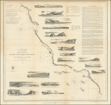
The map and photographs provide one of the last snapshots of the path of Sacatela Creek, one of several active creeks which grew to flood proportions during heavy rains in Los Angeles. The accompanying text provides a very detailed positional analysis of the storm drain and financing.
Sacatela Creek (also called Bimini Slough) ran from its source in Los Feliz's Franklin Hills through Los Angeles. In the 1920s, in order to address frequent floodiing at 6th & Mariposa, it was converted to a series of storm drains, in the same fashion as the LA River. Interestingly, there are still a number of bridges in Los Angeles that were built to cross the original creek.
One of the spots along the creek was likely Bimini Springs, where an early 20th Century bathhouse (Bimini Baths) was built and was a famous local resort spot, attracting Hollywood celebrities and the like and was served directly by a Yellow Car line.
There are still several remnants of the Sacatela Creek lore, including the Sacatela Village Apartments in East Hollywood. Until recently, 6th & Mariposa, was the location ofthe Creekside Cafe.
The promotional map and text are very rare. We were unable to locate another example in OCLC or elsewhere. The present example comes from the S H Woodruff papers.
For a more detailed modern look at Sacatela Creek, view the following link: militantangeleno.blogspot.com/2008/04/river-ran-through-it-in-search-of.html
![[Santa Cruz / Holmes Lime Company] [H.T. Holmes Lot. Area 15 85/100 Acres.](https://storage.googleapis.com/raremaps/img/small/76542.jpg)

![[ Palm Springs - Coachella Valley ]](https://storage.googleapis.com/raremaps/img/small/98853.jpg)