|
||

|

|
|

|
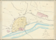
Detailed plan of Pondichery, from a German edition of the Prevost D'Exiles.
The map shows the town plan, neighboring fortifications and River. Includes a key locating essential place names.
The ancient history of Pondicherry is associated with Saint Agasthya, the revered sage of the south. Excavations near Pondicherry have revealed the existence of a Roman settlement some 2000 years ago. It was also the site of many battles between the British, Dutch and French and was also the capital of French India.
Puducherry (or Pondicherry) was a part of the Pallava kingdom of Kanchipuram in the fourth century AD. During the next few centuries Pondicherry was continued to be under the control of several dynasties of the south. In the tenth century A.D. the Cholas of Thanjavur ruled the region for over 300 years but later on it was replaced by the Pandya Kingdom. Till 1638, Pondicherry came under various rulers like the Muslim rulers of the North; the Vijayanagar Empire and then the Sultan of Bijapur came to rule over Gingee.
The French East India Company set up its trading centre at Puducherry in 1673. This outpost eventually became the chief French settlement in India. The Dutch and British trading companies also wanted trade with India. Wars raged between these European countries and spilled over into the Indian subcontinent. The Dutch captured Pondicherry in 1693 but returned it to France by the Treaty of Ryswick in 1699.
During the Anglo-French wars (1742-1763), Pondicherry changed hands frequently. On January 16, 1761, the British captured Puducherry from the French, but the Treaty of Paris (1763) returned the city to the French. It was taken again by the British in 1793 amid the Wars of the French Revolution, but once again returned to France in 1814. When the British gained control of the whole of India in the late 1850s, they allowed the French to retain their settlements in the country. Pondicherry, Mahe, Yanam, Karaikal and Chandernagar remained a part of French India until 1954.
Jacques-Nicolas Bellin (1703-1772) was among the most important mapmakers of the eighteenth century. In 1721, at only the age of 18, he was appointed Hydrographer to the French Navy. In August 1741, he became the first Ingénieur de la Marine of the Dépôt des cartes et plans de la Marine (the French Hydrographic Office) and was named Official Hydrographer of the French King.
During his term as Official Hydrographer, the Dépôt was the one of the most active centers for the production of sea charts and maps in Europe. Their output included a folio-format sea atlas of France, the Neptune Francois. He also produced a number of sea atlases of the world, including the Atlas Maritime and the Hydrographie Francaise. These gained fame and distinction all over Europe and were republished throughout the eighteenth and even in the nineteenth century.
Bellin also produced smaller format maps such as the 1764 Petit Atlas Maritime, containing 580 finely-detailed charts. He also contributed a number of maps for the 15-volume Histoire Generale des Voyages of Antoine François Prévost.
Bellin set a very high standard of workmanship and accuracy, cementing France's leading role in European cartography and geography during this period. Many of his maps were copied by other mapmakers across the continent.
![[Ambon Island] Caart van het Eyland Amboina in 't bijsonder](https://storage.googleapis.com/raremaps/img/small/76744.jpg)
![The Road of Palleacate off the Coast of Coromandell [with] The Road of Tengepatnam or Fort St. David on the Coast of Coromandell](https://storage.googleapis.com/raremaps/img/small/94807.jpg)