![Culiacanae, Americae Regionis, Descriptio [with] Hispaniolae, Cubae, Aliarumqe Insualrum Circumiacientium Delineatio By Abraham Ortelius](https://storage.googleapis.com/raremaps/img/small/86114.jpg)


|
||

|

|
|

|
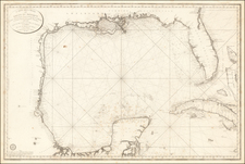
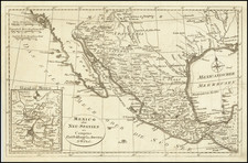
Nice example of Ortelius' maps of South Florida & the Caribbean, along with a regional map of part of Mexico, from the 1579 Latin edition of Ortelius' Theatrum Orbis Terrarum, the first modern atlas of the World.
Ortelius created this map by himself, based upon a number of maps, including Mercator's 1569 world map, Guttierez' 1562 map of America, and Alsons de Sata Cruz' 1560 Isolario. The detail in Flordia and the Caribbean is quite remarkable. The map extends from the tip of the Yucatan and names the Cayman Magnus and the Caymanes, and provides excellent detail for Cuba, Hispaniola, Jamaica and St. Jois Insula (St. Johns). The treatment of the Bahamas, Virgin Islands, and the Windward Islands is also excellent for the period.
Remarkable detail is given in Southern Florida, although not necessarily in accurate fashion. Hints of the Florida Keys are clearly present, making this in reality a better chart of South Florida and the Keys than the Chaves map shown as one of the maps in Ortelius' Peruviae…
Abraham Ortelius is perhaps the best known and most frequently collected of all sixteenth-century mapmakers. Ortelius started his career as a map colorist. In 1547 he entered the Antwerp guild of St Luke as afsetter van Karten. His early career was as a business man, and most of his journeys before 1560, were for commercial purposes. In 1560, while traveling with Gerard Mercator to Trier, Lorraine, and Poitiers, he seems to have been attracted, largely by Mercator’s influence, towards a career as a scientific geographer. From that point forward, he devoted himself to the compilation of his Theatrum Orbis Terrarum (Theatre of the World), which would become the first modern atlas.
In 1564 he completed his “mappemonde", an eight-sheet map of the world. The only extant copy of this great map is in the library of the University of Basel. Ortelius also published a map of Egypt in 1565, a plan of Brittenburg Castle on the coast of the Netherlands, and a map of Asia, prior to 1570.
On May 20, 1570, Ortelius’ Theatrum Orbis Terrarum first appeared in an edition of 70 maps. By the time of his death in 1598, a total of 25 editions were published including editions in Latin, Italian, German, French, and Dutch. Later editions would also be issued in Spanish and English by Ortelius’ successors, Vrients and Plantin, the former adding a number of maps to the atlas, the final edition of which was issued in 1612. Most of the maps in Ortelius' Theatrum were drawn from the works of a number of other mapmakers from around the world; a list of 87 authors is given by Ortelius himself
In 1573, Ortelius published seventeen supplementary maps under the title of Additamentum Theatri Orbis Terrarum. In 1575 he was appointed geographer to the king of Spain, Philip II, on the recommendation of Arias Montanus, who vouched for his orthodoxy (his family, as early as 1535, had fallen under suspicion of Protestantism). In 1578 he laid the basis of a critical treatment of ancient geography with his Synonymia geographica (issued by the Plantin press at Antwerp and republished as Thesaurus geographicus in 1596). In 1584 he issued his Nomenclator Ptolemaicus, a Parergon (a series of maps illustrating ancient history, sacred and secular). Late in life, he also aided Welser in his edition of the Peutinger Table (1598).
![El numero 1 q[ue] se haya en la orilla de la ???ya que corre a San Ysidro es el gran ?? de partida siguencio? la numeracion immediata a los puntos amarillos ?on los ?inderos, hasta? el numero 19 con que vierra en el terreno marcados con la letra C.](https://storage.googleapis.com/raremaps/img/small/65664ba.jpg)