
![Charte von Den Vereinigten Staaten von Nord-America nebst Louisiana . . . 1805 [Rare 1st State of Gussefeld's Louisiana Purchase Map] By Franz Ludwig Gussefeld](https://storage.googleapis.com/raremaps/img/small/63496.jpg)


|
||

|

|
|

|
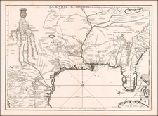
Rare later variant edition of Gussefeld's map of the US, published in the same year as the Louisiana Purchase and highlighting Jefferson's US on the eve of the expedtitions of Lewis & Clark, Zebulon Pike, etc.
Following the Louisiana Purchase in 1805, there was a tremendous push to chart and explore the new American West. Gussefeld's map is illustrative of the extent of contemporary knowledge of the area purchased by Jefferson in 1803, including conjectural mountain ranges in the regions north and south of the Missouri River, scattered Indian Tribes and lots of conjecture.
This edition, dated 1805, post-dates a second map of the same title, also by Gussefeld, which was almost certainly issued earlier in the same year. Here is a link to the earlier 1805 edition: www.raremaps.com/gallery/enlarge/22753
The notable differences include (1) Ohio located differently on the present map (just below Lake Erie), where as in the earlier map, it is above Kentuck and untitled., In the earlier map the lands below the "Erie See" are part of Ohio. In the later map, they are part of Indiana; 2) North Carolina's eastern border follows the Appalachians; 3) there is no sign of Mississippi Territory, whereas the outline for Mississippii Ter is already laid out, and 4) The western boundaries of the Carolinas are now more closely shown and accurately so.
A massive Indiana Territory extends nearly to Winnepeg. Ohio is badly misprojected. A fascinating inaccurate Tennessee-North Carolina border, immediately after the disappearance of Franklin. East & West Florida are shown, along with Mississippi Terr prior to Alabama. Full of early exploration notes, anomalous state & territorial borders, early forts, trading posts, etc.
Great attention to detail was given in revising this map.

![(Civil War) Fredericksburg … [with] Map… of the Sioux Expedition [with] Map of the Fight of the 14th A.C. Buzzard Roost, GA [and ] Big Mound [and] Dead Buffalo Lake [and] Dry Fort Creek](https://storage.googleapis.com/raremaps/img/small/97072.jpg)