|
||

|

|
|

|
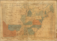
Fine example of Richard Bennett's reduced size example of the Society for Anti-Gallicans Map of the the English Empire in North America, which appeared in Grand Magazine of Universal Intelligence and Monthly Chronicle of our Own Times, volume. 1, October 1758.
As noted in the description of the map in the Pennsylvania Archives, the map includes the same title and same cartography as The Society for Anti-Gallicans map of 1755. Published in the same year as John Mitchell's map of North America, the Society of Anti-Gallicans' map is without peer in its blatent effort to combat the French claims in North America. The maps leaves only one relatively small uncolored area, an unnamed Quebec Province, as the only area which is not the rightful possession of Great Britain, with highly exaggerated boundaries throughout. As noted by Mary Pedley:
the Anti-Gallican map differs from other printed maps of 1755 [in its use of] readily available French and British cartographical sources to create a powerful image of an expanding overseas empire facing an internal threat that could only be defeated by the use of arms. The incorporation of subtle propaganda into the map's design reflects a concerted effort on the part of the map's compiler to promote the cause of the Anti-Gallicans, who sought independence from French commerce and design influence.
The map shows the boundaries of New York, Virginia, North Carolina, South Carolina and Georgia all extending west of the Mississippi, through Louisiana and on to the Pacific Coast, with the boundary of the Hudson's Bay Company (according to the Treaty of Utrecht), also extending to the Pacific. The map identifies a number of the early (and offending) French Forts, including those just south of the Falls of St. Anthony, Green Bay and Lake Huron and a number of other forts on the Missouri and Mississippi Rivers, along with the the strategic English forts on the Ohio, Wabash, Connecticut and Illinois Rivers, along with English forts near Lake Champlain and Lake George and those in Georgia. The map includes inset plans of the Towns and / or Fortifications at Fort Frederick (Crown or Scalp Point), Fort Dauphin on Cape Breton Island, Annopolis Royal, Quebeck, Louisbourg and Chebucto, along with an inset map of the Atlantic Coast and Ocean.
As noted in by the Osher Library Worldly Treasures on-line exhibition of this map:
The early 1750s were marked by increasingly fierce competition between England and France for control of North American territory and commerce, especially the lucrative fur trading and fishing. Both countries issued proclamations, pamphlets, and maps in support of their conflicting claims, each accusing the other of illegal "encroachments." The French vigorously asserted their sovereignty over the entire watersheds of the St. Lawrence and Mississippi Rivers, including the Great Lakes and Ohio River valley. The British grudgingly conceded only the Canadian regions north of the St. Lawrence River from the Ottawa River ("R. Outaouais") to the Bustard River ("R. Bustard"), the islands in the Gulf of St. Lawrence, a narrow strip of the northern coast of Newfoundland, and lands immediately adjacent to French settlements.
These areas, described as "French Possessions and Encroachments," are left uncolored on the map. Tensions steadily mounted until 1755, when the "map wars" gave way to bloody armed conflict: The French and Indian War. This map, made after the onset of hostilities, is perhaps the most blatant of the British propaganda maps. The issuers, a "Society of Anti-Gallicans," make no pretense of impartiality, and present an aggressive and overtly partisan statement of British territorial claims. The title of the map describes the British position as a "Rightful claim as confirm'd by Charters," and refers to the "Encroachment of the French, with the several Forts they have unjustly erected" [emphasis added]. Inscriptions and colored lines define exaggerated British claims which are, in fact, "encroachments" on New France!
The present example is the rare first edition of the map, pre-dating the annotations which appears on the later issue. The text on later issues of the map states "purple line represents the Western Boundary of the hereditary & Conquer's Country of our Indian Friends & Allies, which has been ceded and confirm'd to us by several Treaties and Deeds of Sale."
The Society or Order of Anti-Gallicans was organized in response to the renewed hostilities with France. Officially its aims were patriotic, though they were more likely economic in nature and concerned with slowing or preventing the flow of French goods into England. Established by about the end of 1751, the Order appointed distinguished presidents, including Lord Carpenter and Sir Edward Vernon, held regular meetings, outfitted at least one privateer charged with harrying the French at sea, published patriotic songs, anti-French prints, at least one novel (The Anti-Gallican, or the History and Adventures of Sir Henry Cobham London: 1757) and one map.