|
||

|

|
|

|
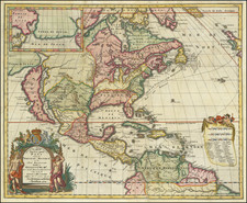
Rare separately issued map of America by George Foster in London.
Fascinating separately issued map, which includes a number annotations of interest to the British public in the first half of the 18th Century. The route of Captain James and Henry Hudson in search of the northwest passage, along with the tracts of Button and several others who explored Hudson's Bay, Baffin Bay, Button's Bay etc. in the first half of the 17th Century.
The treatment of the British Colonies in North America is unusually detailed for te period. Lahontan's Longue River is shown, extending nearly to the Pacific Coast, although with no sign of the mountain ranges noted in his original map. California is shown as an island, one of the last English maps to retain this cartographic myth.
Several interesting insets are included, most notably a very early treatment of the Coastline of Georgia, Boston Harbour and Port Royal Harbour, along with a larger inset map of the North Pole (based upon Moll's map and an inset vignette of the Cod Fisheries. The inset of Georgia is especially interesting, being one of the earliest printed maps to name Georgia.
In the Atlantic, there are several annotations on the route of the Spanish Galleons and arrows showing the prevailing currents.
The present example is state 3 of 5, all of which are exceptionally rare. A variant edition was issued with significant revisions by Laurie & Whittle circa 1794: /gallery/detail/22714
Only the second time we have seen the map in 20 years.

![La America Dispuesta segun las ultimas y nuevas observationes de las Accademias, y de Paris, y de Londres [Bay or Sea of the West--Very Rare]](https://storage.googleapis.com/raremaps/img/small/75936.jpg)