|
||

|

|
|

|
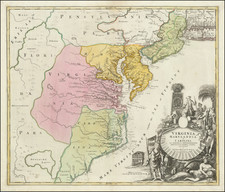
Rare and highly important map of the Roads and Canals of Maryland, Pennsylvania, New Jersey, Delaware and part of New York, at the end of the 18th Century, with an important 18th Century provenance.
Important early American imprint, showing the existing roads and planned internal improvements for Western settlement. Following the American Revolution, Pennsylvania bought what land remained in the state from its native tribes, and acquired from the Federal Government the rights to the "Erie Triangle" in the northwesternmost portion of the state. Land speculation and surveying of the western portions of the state began in earnest and The Society for Promoting the Improvement of Roads and Inland Navigation was formed in 1789, with Robert Morris as President.
Amongst those involved with both the Society and the surveying of the state were John Adlum and John Wallis. Wallis was the eldest son of Samuel Wallis, among the largest land speculators, or "land-jobbers" as they were called at the time. Adlum, born in York, Pennsylvania, began working as an independent surveyor at Northumberland in the mid-1780s and in 1787 was appointed to help survey the northern boundary of the state. "In April, 1790, [Adlum] was appointed with Timothy Matlack and Samuel Maclay to a commission to explore the 'western waters' and find the best routes of communication into Pennsylvania's new lands" (Kent & Deardorff). Evans (23104) states that the copyright was issued in February 1791, and the title registered contained the following statement: "Compiled . . . at the particular request of the Society lately formed in Pennsylania, for promoting the Improvements of Roads and Inland Navigation."
In 1791, Robert Morris, on behalf of the Society, submitted to the Pennsylvania Legislature "A proposal and plan for carrying into immediate execution the improvement of roads and inland navigation." That document concludes with the report that the "Society have directed an accurate geographical and hydrogrical map to be compiled from actual surveys, exhibiting a general and compleat view of the roads and water communications, which are proposed to be improved, connecting them with the roads and water communications of the neighboring states" (published within William Smith's An Historical Account of the Rise, Progess and Present State of the Canal Navigation in Pennsylvania). The Adlum-Wallis map more clearly depicts both existing, planned and proposed roads and canals, and shows much more of Pennsylvania's neighboring states, suggesting that Morris was referring to this map.
The illustrations on the map show a Sketch of a Lock Full of Water, Section of a Lock, and Plan of a Lock. These illustraions would later be reproduced in Dobson's Encyclopedia.
The present example is in an original slip case and bears the imprint of R.H. Hooper Esq. Robert Lettis Hooper (1737?-1797) was a New Jersey "patriot" who served as Deputy Quartermaster General in the Continental Army and, later, became involved in the iron industry in New Jersey, particularly in Ringwood. Hooper owned a grand estate, Belleville, along the Delaware in Trenton (and had land holdings in Rocky Hill and elsewhere), and was a member of the governor's council, &c. He also did some surveying in western Pennsylvania. Hooper, Wallis and Adlum were part of a small group of Pennsylvania land speculators who, primarlily led by Samuel Wallis, were actively purchasing land in Western Pennsylvania.
John Adlum was born in York, Pennsylvania, April 29, 1759. Adlum learned surveying and in 1789, was directed by Surveyor General Lukens to re-survey in the northwestern part of the state. That same year he was commissioned by the state, on recommendation of William Maclay, Benjamin Rush, John Nicholson and Colonel Thomas Hartley, to study the Susquehanna with a view to its navigation, and subsequently with Benjamin Rittenhouse to examine the Schuylkill river. He was also associated with Samuel Maclay and Colonel Timothy Matlack as commissioners, by appointment of the Supreme Executive Council, to survey the West Branch of the Susquehanna, the Sinnemahoning and Allegheny rivers, in 1790. The object of these surveys was to ascertain if communication could be established with Lake Erie. The same year, he also entered the employ of Samuel Wallis to make surveys.
Adlum called upon several times to meet with the Indians for the purpose of making treaties, and in 1791, he and Colonel Pickering met a body of 100 Indians at Newtown (Elmira). About this time he settled near Muncy where he had taken up a large amount of land, and built a stone house still known today as the Adlum house. During his residence in this county, he made extensive surveys of land, and also served as agent for William Bingham. Th Lycoming County Deed Book 1, page 60, contains the Articles of Agreement entered into between Samual M. Fox et. al., and John Adlum regarding the survey of one and a half million acres of land lying on both sides of the Allegheny mountains.
Samuel Wallis was born in Harford County, Maryland, about 1730. At one time he had been a shipping merchant. He also studied surveying, and became interested in speculation in Pennsylvania lands as soon as this area came into the market. As the result of being employed by Judge James Wilson, Signer of the Declaration of Independence and agent for the Holland Land Company, as a surveyor, Wallis was able to acquire the choicest parcels for himself. In time he became the largest land owner and the most active dealer in lands in Westrn Pennsylvania, sometimes individually, and sometimes in ventures with Wilson, Henry Drinker, Abel James, Reuben Haines, Robert Lettis Hooper and John Adlum.
During the American Revolution, it is believed that Wallis was secretly working for the British as a spy, and Benedict Arnold's agent. The Clements Library holds records showing payments by the British to Wallis during the course of the War.
Only 1 example of the map has appeared at auction in over 40 years (Jay T. Snider Collection--Bloomsbury, 2008). Wheat & Brun list 6 locations (Library of Congress, Yale, Clements, New York Historical Society, Boston Public Library, Library Company of Philadelpia).
![A New and Exact Map of the Dominions of the King of Great Britain on ye Continent of North America . . . [Beaver map]](https://storage.googleapis.com/raremaps/img/small/101277.jpg)