


|
||

|

|
|

|
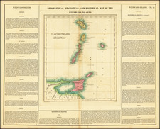
Detailed map of the Windward Islands, from Carey & Lea's rare American Atlas.
The text surrounding the map is of particular note.
Includes the region from Martinique to Trinidad & Tobago. Carey & Lea's Atlas is highly prized not only for its cartographic information but the marvelous information about each of the states and territories included. The atlas was issued in 6 editions in English, French & German between 1822 and 1827.
Henry Charles Carey (1793-1879) was an American geography publisher and businessman. He was the son of Mathew Carey and carried on the family publishing company in partnership with his brother-in-law, Isaac Lea. Henry worked in his father’s business from a young age. At twelve, he managed a store selling his father’s publications. At fifteen, he was the firm’s financial manager. In 1817, he became a junior partner, which changed the company’s name to Carey & Son.
In 1822, Mathew Carey brought in a new junior partner, Isaac Lea, who had married Henry’s sister, Frances Anne. In the same year, Mathew Carey left the business, with Henry buying out his father’s share. His younger brother briefly joined the business, but left by 1829, when the firm was named Carey & Lea. William A. Blanchard joined the firm in 1833, causing another name change to Carey, Lea & Blanchard. Henry retired in 1835, leaving the firm as Lea & Blanchard.
Henry had outside interests, including political economy. He published Principles of Political Economy in 1837. He also wrote Past, Present, and Future (1848), Principles of Social Science (1858-1860), and The Unity of Law (1872). In the 1850s, he was very active in organizing the nascent Republican Party. He died in 1879.
Isaac Lea (1792-1886) was an American publisher and geologist. Raised a Quaker in Delaware, he turned away from pacifist teachings and joined the militia in the War of 1812. After marrying Frances Anne, the daughter of publishing magnate Mathew Carey, Lea became a junior partner of Carey & Son in 1822. Mathew Carey left the firm in the same year and Isaac Lea worked primarily with his brother-in-law, Henry Charles Carey.
The pair conducted business as Carey & Lea, during which time they published A Complete Historical, Chronological and Geographical Atlas from 1822 to 1827. This work included roughly twenty maps engraved by Fielding Lucas Jr., as well as an American edition of Starling’s Cabinet Atlas. However, the firm increasingly turned away from cartographic publications.
By 1829, after the brief participation of Edward Carey, Henry’s younger brother, the company became known as Carey & Lea. William A. Blanchard joined the firm in 1833, causing another name change to Carey, Lea & Blanchard. Henry retired in 1838, leaving the firm as Lea & Blanchard.
Isaac Lea was not just a publisher, but an avid researcher with aptitude for geology. He was a member of the American Academy of Natural Sciences and the American Philosophical Society. He retired from publishing in 1851 and turned increasingly to geological research, results of which he published until his death in 1886.
![Cuba Insula [with] Hispaniola Insula [with] Ins. Jamaica [with] Ins. S. Ioannis [with] I.S. Margareta [with] Havana portus](https://storage.googleapis.com/raremaps/img/small/95302.jpg)
![Carta General de las Islas Antillas Menores [North sheet]](https://storage.googleapis.com/raremaps/img/small/93244.jpg)
![[St. Kitts / St. Christopher] Carta De La Isla De San Christoval Reducida y Gravada, Por D. Juan Lopez . . . 1780](https://storage.googleapis.com/raremaps/img/small/84337.jpg)