


|
||

|

|
|

|
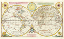
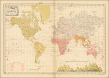
Fine dark impression of Peter Apian's 1520 World Map, the first obtainable map to name America.
Peter Apian's 1520 World Map is one of the most important early maps of the World. For many years, it was believed that Apian's map was the first map to use the name America, as well as the earliest to utilize the a truncated cordiform (heart shaped) projection. It was not until the discovery in 1901 of the sole survivng example of Waldseemuller's 12-sheet map of the World, published in 1507, that the true source of Apian's map was the Waldseemuller map, which is known in a single example (purchased by the Library of Congress from its original German owners in 2001 for $10,000,000).
As noted by Shirley, Apian's map faithfully follows the Waldseemuller model with "a close geographic correspondence, a similarity of woodcutting style, and the same truncated cordiform." There is one significant improvement in Apian's map, the creation of a passage from the Atlantic to the Pacific Ocean which is not present in Waldseemuller's map of the world. The timing of the change corresponds to the departure of Ferdinand Magellan in search of a passage from the Atlantic to the Pacific and supports the theory that Magellan was aware of prior voyages of exploration which had reached the Pacific, which are not well documented in modern times.
Laurent Fries, whose initials appear on the map, was almost certainly the engraver of the map. In 1522, Fries would complete an updated edition of Waldseemuller's Geographiae, including 2 world maps derived from Waldseemuller.
During the 16th Century, the quest for geographical knowledge was primarily spurred on by trade. The great trading nations of Europe became leaders in the printing of maps. Because of its location connecting land routes to the east and southeast, Germany became one of the pre-eminent map centers. Peter Apian, also known by his Latin name Petrus Apainus, was professor of mathematics and was known as a great astronomer. These skills combined with his interest in geography led to the establishment of his own printing press in Landshut. Apian's textbook Cosmographicus Liber was first published in 1524. The fourth edition (1529) and later editions were edited by his pupil Gemma Frisius, who inserted his own world map in the 1545 publication.
![[ Pre-Columbian World Map; ] Secunda etas mundi](https://storage.googleapis.com/raremaps/img/small/98195.jpg)