|
||

|

|
|

|
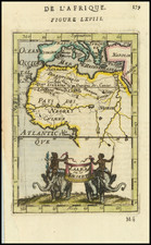
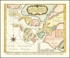
Nice old color example of Louis Renard's sea chart of the Southwestern Coast of Africa.
Striking sea chart, with detailed treatment of the coastal regions, rhumb lines, compass roses, elaborate cartouches and sailing ships.
By the second half of the 17th century, the Dutch had established a strong presence on the southwestern coast of Africa. The chart illustrates a rugged coastline with place names that include European trading posts and a larger inset of the area around the Cape of Good Hope, a strategically significant point in the trading out between Europe and the Indian Ocean.
The European colonies in the region were primarily Dutch and Portuguese, with the Dutch dominating the southern parts of the region and the Portuguese the northern parts. The Dutch colony of Cape Town, founded in 1652, was a key center of Dutch influence in the region. The colony grew rapidly, attracting settlers from Europe and slaves from Asia and Africa, and it soon became a major hub for trade and commerce in the region. The Portuguese, meanwhile, had established settlements in Angola and Mozambique, and they also had a strong presence in the region's coastal trade networks.
European trade and commerce in the region during the second half of the 17th and first half of the 18th centuries was dominated by the transatlantic slave trade. Dutch and Portuguese ships were among the most active participants in this trade, which involved the transportation of millions of enslaved Africans to the Americas. The southwestern coast of Africa was a key source of slaves for the transatlantic trade, with large numbers of people being captured and sold into slavery by local African rulers and traders.
In addition to the slave trade, European trade and commerce in the region during this period also included the exchange of a variety of other goods, including ivory, gold, and spices. The Dutch were particularly interested in the region's elephant ivory, which was highly prized in Europe for its use in luxury goods and carvings.
![[Luanda, Angola] Eroberung der Statt Loando de Sanct Paolo in Angola in Africa. Gelegen](https://storage.googleapis.com/raremaps/img/small/85194.jpg)