


|
||

|

|
|

|
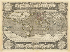
Striking, Finely Engraved Example of Ortelius' Landmark World Map
One of the most famous world maps ever made, "Typus Orbis Terrarum" featured in the world's first atlas, Theatrum Orbis Terrarum. Abraham Ortelius (1527-1598) included the work as the first map in his atlas and it went through three editions in the later sixteenth century.
The map includes a massive Terra Australis Nondum Cognita, a distinctive Northwest Passage below the Terra Septemtrionalis [sic.] Incognita, and other early cartographic hypotheses. The early mis-projection of Japan is prominent, as is the equally conjectural depiction of New Guinea and the Solomon Islands. North America is a study in guesswork and mythical cartography, including a projection of the St. Lawrence reaching to the middle of the continent and a similar river running from the Gulf of Mexico to the same vicinity. Nova Francia is shown, although the map debuted well before the visits of Champlain and the Jesuits.
The map is based most directly upon Mercator's map of 1569, Gastaldi's map of 1561, and Diego Gutierrez' portolan map of the coastlines of the Atlantic.
Cartographic compilation and guesswork
Although the map appears woefully erroneous to modern eyes, it actually contains some of the best compilation work of the period, which was a hallmark of mapmaking in the sixteenth century. Additionally, Ortelius and his colleagues corrected the map as they released new editions of his atlas; for example, the western bulge in South America was removed in the third state of the second edition of the world map.
Many other place names and geographic features remain that were based on dubious sources or hypotheses that have since been corrected. For instance, only the Straits of Magellan separate South America from the large, unknown southern continent. This was common to maps of the period, as a southern continent was thought likely to be hidden in the Pacific and near the South Pole to balance the continents of the northern hemisphere.
Points on that continent derived from sailors' stories and observations. Take, for example, Psitacorum regio, south of the Cape of Good Hope. Psitacorum regio appeared on Mercator's 1541 globe and his 1569 world map. It was supposed to have been sighted by Portuguese sailors. Farther west, a pot-bellied depiction of New Guinea is accompanied by a cautionary note, admitting that New Guinea may actually be connected to Terra Australis.
Further east on the southern continent are several place names: Beach, Lucach, and Maletur. They would be familiar to anyone who has read Marco Polo's Travels. These three places were regions in Java. As can be seen, a Java minori is near to Maletur. This conflation of Java with the southern continent stemmed from an error. Initially, Polo used Arabic usage of Java Major for Java and Java Minor for Sumatra. After a printing mistake made Java Minor seem the largest island in the world in the 1532 editions of Polo's Travels (Paris and Basel), mapmakers started to make a landmass to accommodate Java Minor, Beach, Lucach, and Maletur.
An intriguing place name lies in the far northwest of North America. Anian derives from Ania, a Chinese province on a large gulf mentioned in Marco Polo's travels (ch. 5, book 3). The gulf Polo described was actually the Gulf of Tonkin, but the province's description was transposed from Vietnam to the northwest coast of North America. The first map to do so was Giacomo Gastaldi's world map of 1562, followed by Zaltieri and Mercator in 1567. The Strait then became shorthand for a passage to China, i.e. a Northwest Passage. It appeared on maps until the mid-eighteenth century.
Quivira, south of Anian, refers to the Seven Cities of Gold sought by the Spanish explorer Francisco Vasquez de Coronado in 1541. In 1539, Coronado wandered over what today is Arizona and New Mexico, eventually heading to what is now Kansas to find the supposedly rich city of Quivira. Although he never found the cities or the gold, the name stuck on maps of southwest North America, wandering from east to west. Here it is used to describe the entire southwest of the North America.
Both places were en route to a clear Northwest Passage that wends its way north of what is now Canada to Europe. Similarly, there is a clear Northeast Passage over Russia. The possibility of a Northwest Passage is an idea that still transfixes geographers today; we are still revising our maps, just like Ortelius did.
Ortelius' atlas and the states of "Typus Orbis Terrarum"
The influence of this and other Ortelius maps stems from the popularity and dominance of his atlas in the European market. In 1570, Ortelius published the first modern atlas; that is, a set of uniform maps with supporting text gathered in book form. Previously, there were other bound map collections, specifically, the Italian Lafreri atlases, but these were a mix of maps-not necessarily uniform-selected and bound together on demand.
Theatrum Orbis Terrarum, Ortelius' atlas, outperformed competing atlases from other cartographic luminaries like the Mercator family. Between 1570 and 1612, 31 editions of the atlas were published in seven languages.
This map first appeared in the very first 1570 atlas and eventually ran through three editions with several states of each, as the plates were revised. The first was signed by Frans Hogenburg (ca. 1540-ca. 1590), a Flemish and German engraver and mapmaker who also painted. Together with his father, brother (Remigius), uncle, and cousins, Frans was one member of a prominent artistic family in the Netherlands.
The first plate was used in the first sixteen editions of the Theatrum, which included editions in Latin, Dutch, German, and French. Around 1575, the plate became cracked in the lower left-hand corner; state two shows bolt impressions, a temporary fix. Later, the plate was reworked; this revised third state of plate one ran in editions from 1579. A fourth state appeared in 1584 with the date "1584" added to Hogenberg's signature. The final state of plate one, the fifth state, has the date 1585.
The second plate had three states, the first dated 1586, the second undated, and the third with the coastline of South America fixed so as to omit the western bulge.
The third plate, dated 1587 (but not seemingly used until 1592), has medallions in the corners and a new border. A second state of plate three, dated ca. 1628, included the Strait of Le Maire near the Straits of Magellan and eliminated the previous date of 1587.
Whatever the state or edition, this map is central to any collection of antique maps and represents a huge shift in the history of mapmaking. It is the hallmark world map of the first atlas ever published.
Abraham Ortelius is perhaps the best known and most frequently collected of all sixteenth-century mapmakers. Ortelius started his career as a map colorist. In 1547 he entered the Antwerp guild of St Luke as afsetter van Karten. His early career was as a business man, and most of his journeys before 1560, were for commercial purposes. In 1560, while traveling with Gerard Mercator to Trier, Lorraine, and Poitiers, he seems to have been attracted, largely by Mercator’s influence, towards a career as a scientific geographer. From that point forward, he devoted himself to the compilation of his Theatrum Orbis Terrarum (Theatre of the World), which would become the first modern atlas.
In 1564 he completed his “mappemonde", an eight-sheet map of the world. The only extant copy of this great map is in the library of the University of Basel. Ortelius also published a map of Egypt in 1565, a plan of Brittenburg Castle on the coast of the Netherlands, and a map of Asia, prior to 1570.
On May 20, 1570, Ortelius’ Theatrum Orbis Terrarum first appeared in an edition of 70 maps. By the time of his death in 1598, a total of 25 editions were published including editions in Latin, Italian, German, French, and Dutch. Later editions would also be issued in Spanish and English by Ortelius’ successors, Vrients and Plantin, the former adding a number of maps to the atlas, the final edition of which was issued in 1612. Most of the maps in Ortelius' Theatrum were drawn from the works of a number of other mapmakers from around the world; a list of 87 authors is given by Ortelius himself
In 1573, Ortelius published seventeen supplementary maps under the title of Additamentum Theatri Orbis Terrarum. In 1575 he was appointed geographer to the king of Spain, Philip II, on the recommendation of Arias Montanus, who vouched for his orthodoxy (his family, as early as 1535, had fallen under suspicion of Protestantism). In 1578 he laid the basis of a critical treatment of ancient geography with his Synonymia geographica (issued by the Plantin press at Antwerp and republished as Thesaurus geographicus in 1596). In 1584 he issued his Nomenclator Ptolemaicus, a Parergon (a series of maps illustrating ancient history, sacred and secular). Late in life, he also aided Welser in his edition of the Peutinger Table (1598).
![[ WWI Anti-German Propaganda ] Le Plan Pangermaniste](https://storage.googleapis.com/raremaps/img/small/63622.jpg)
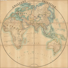
![The Western Hemisphere... [with:] The Eastern Hemisphere A Stereographical Projection on the Twentieth Meridian](https://storage.googleapis.com/raremaps/img/small/97573.jpg)