


|
||

|

|
|

|
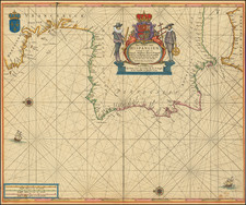
Fine old color example of this beautiful chart of the coastlines of Southern Europe, by Pieter Goos. Published in 'De Zee-Atlas Ofte Water-Weereld'.
This finely executed chart, oriented with east at the top of the map, extends from the Straits of Gibraltar in the south to Bretagne in the North, providing fine coastal details along the Bay of Biscaya and the Iberian Peninsula. The chart is surmounted by a decorative cartouche and ornate coat of arms, with the French coat of arm in the upper left and multiple compass roses and sailing ships embellishing the seas.
A striking wide margined example, in fine old color.
Pieter Goos (ca. 1616-1675) was a Dutch map and chart maker, whose father, Abraham Goos (approx. 1590-1643), had already published numerous globes, land and sea maps together with Jodocus Hondius and Johannes Janssonius in Antwerp. Pieter gained recognition due to the publication of sea charts. He bought the copperplates of the famous guide book for sailors, De Lichtende Columne ofte Zeespiegel (Amsterdam 1644, 1649, 1650), from Anthonie Jacobsz. Goos published his own editions of this work in various languages, while adding his own maps. In 1666, he published his De Zee-Atlas ofte Water-Wereld, which is considered one of the best sea atlases of its time. Goos' sea charts came to dominate the Dutch market until the 1670s, when the Van Keulen family came to prominence.
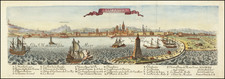
![Neuester und exacter Plan und Prospect von der Stadt Vestung Bay und Fortification Von Gibraltar…1733 [with view of Cadiz]](https://storage.googleapis.com/raremaps/img/small/91413.jpg)
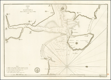
![Valetta, the Capital of the Island of Malta [with] Balearic Islands [and] Corsica and Sardinia](https://storage.googleapis.com/raremaps/img/small/60552.jpg)