The item illustrated and described below is sold, but we
have another example in stock. To view the example which
is currently being offered for sale, click the
"View Details" button below.


|
||

|

|
|

|
Stock# 2576
Description
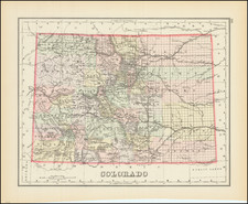
Detailed map, colored by counties and showing Indian Reservations, mountains w/elevations, lakes, some townships, roads, railroads, stations, towns, etc. One of the best regional maps of Colorado to appear in an atlas and one of the earliest to show Colorado as a single state.
O.W. Gray Biography
O. W. Gray was a publishing firm based in Philadelphia. Later, they published as O. W. Gray & Son. They published atlases in the late nineteenth century. Gray's National Atlas was one of the most successful commercial ventures of the 1870s and one of the last to employ hand coloring on maps.
![[ Idaho Below Montana ] Verein-Staaten am Stillen Ocean… [inset of San Francisco Bay] [Unusual Idaho & California configurations]](https://storage.googleapis.com/raremaps/img/small/99297.jpg)