|
||

|

|
|

|
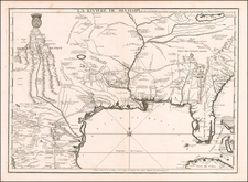
Early English plan of New Orleans by Thomas Jefferys, one of London's top map makers during the period prior to the American Revolution.
The map shows a detailed plan of New Orleans, at the start of the French & Indian War, providing a detailed overview of the town, including street names, building locations and the names of important public locations, civilian and military, with a inset key of other place names in the upper left corner. The four major roads into New Orleans are also shown, along with a detailed study of the Mississippi River in 2 insets on the right side of the map. Following the Treaty of Paris in 1763, New Orleans would become one of 2 French Outposts in North America, after the French conceded their rights to all of their North American colonial possessions, except New Orleans and two important islands for retention of fishing rights in the Grand Banks.
Jefferys finely executed map is one of the earliest obtainable maps of city of New Orleans itself, founded in 1717 by the Sieur d'Iberville. As noted in the title of the map, it is largely based on the original manuscript plan of the city drafted by Le Blond de la Tour in 1722, and draws also upon Bellin's plan of 1744, which had first appeared in Charlevoix. The outlines of the buildings are detailed, and major structures are labeled, such as the "Parish Church" of St. Louis, the monastery of the "Capuchin-Fryars", the 'House of the Indendant", and the "Hospital and Convent of the Ursulines," the latter being the oldest building in the city that survives to this day.
In Charting Louisiana, Magill states that Jefferys' map includes several interesting and important details that Mr. de la Tour's map lacked or were constructed after his manuscript was constructed, having primarily to do with flood control, which had been an important problem for the French from the initial years of the City. On the banks of the Mississippi, Jefferys notes a "Bank to preserve the Town from the Inudation." Just beyond this are moats created in 1729. The map also shows gutters and footbridges, as well as buildings built after 1721.
The map appeared in The natural and civil history of the French dominions in North and South America. Giving a particular account of the climate, soil, minerals, animals, vegetables, manufactures, trade, commerce, and languages ... Illustrated by maps and plans of the principal places, collected from the best authorities, and engraved by T. Jefferys, Geographer to his Royal Highness the Prince of Wales. Part I. Containing a description of Canada and Louisiana. London, Printed for Thomas Jefferys at Charing-Cross. MDCCLX.
Thomas Jefferys (ca. 1719-1771) was a prolific map publisher, engraver, and cartographer based in London. His father was a cutler, but Jefferys was apprenticed to Emanuel Bowen, a prominent mapmaker and engraver. He was made free of the Merchant Taylors’ Company in 1744, although two earlier maps bearing his name have been identified.
Jefferys had several collaborators and partners throughout his career. His first atlas, The Small English Atlas, was published with Thomas Kitchin in 1748-9. Later, he worked with Robert Sayer on A General Topography of North America (1768); Sayer also published posthumous collections with Jefferys' contributions including The American Atlas, The North-American Pilot, and The West-India Atlas.
Jefferys was the Geographer to Frederick Prince of Wales and, from 1760, to King George III. Thanks especially to opportunities offered by the Seven Years' War, he is best known today for his maps of North America, and for his central place in the map trade—he not only sold maps commercially, but also imported the latest materials and had ties to several government bodies for whom he produced materials.
Upon his death in 1771, his workshop passed to his partner, William Faden, and his son, Thomas Jr. However, Jefferys had gone bankrupt in 1766 and some of his plates were bought by Robert Sayer (see above). Sayer, who had partnered in the past with Philip Overton (d. 1751), specialized in (re)publishing maps. In 1770, he partnered with John Bennett and many Jefferys maps were republished by the duo.


![[ Gulf Coast & West Coast of Florida ] De Cust van Westindien Van La Desconoscida, tot C. Escondido. . .](https://storage.googleapis.com/raremaps/img/small/65741.jpg)