This item has been sold, but you can enter your email address to be notified if another example becomes available.


|
||

|

|
|

|
Stock# 24937
Description
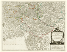
Detailed map of the lower Danube, extending from Belgrade to the Black Sea.
The map extends to Constantinople and the Bosphorus Straits in the southeast to the Ukraine and Podolia in the northeast, and from northern Greece in the southwest to the southern part of the Kingdom of Poland in the northwest, centered on Bulgaria and Valachia.
Condition Description
Minor discoloration at centerfold. Old Color. Double thick paper.
Reference
Szantai, L. Visscher 4a
![The Severn or Channel of Bristol [with a chart of the Irish Sea.]](https://storage.googleapis.com/raremaps/img/small/47485.jpg)
![[Greece & Turkey] Tabula Europae IX](https://storage.googleapis.com/raremaps/img/small/60122.jpg)
![[War pf Austrian Succession]. Theatrum Belli Sive Novissima Tabula Qua Maxima Pars Danubii Et Praeserium Hungaria Cum Aliis Adiacentibus Regnis Nec Non Graecia, Morea, et Archipelagi Insulae…](https://storage.googleapis.com/raremaps/img/small/89541.jpg)