|
||

|

|
|

|
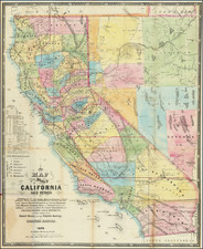
Nice example of De Groot's highly important map of the Washoe Mines, the first map to show the mining region and perhaps the single most important early map in the history of the yet to be formed Nevada Territory.
The map is a tremendous source of information, both for its details in the portion of Utah Territory which would become Nevada and the routes used by California Gold Miners to the newly discovered diggings. The key identifies towns, ranchos, mining camps, wagon roads, mountain trails, ditches etc. As an early source of information for the region, it is unsurpassed.
Henry De Groot was one of the first miners to make the trip from California to "Western Utah" in June 1859, to chase his fortune mining at the newly discovered Comstock Lode. Over the course of the next several years, he would prepare several manuscript maps, two printed maps and a 24 page pamphlet, which would become the first published maps and descriptions of the future Nevada Territory and the foundational source of information for the region. In Volume 4 of his Mapping the Transmississippi West, Carl Wheat states:
This is a map of the first quality, showing the emigrant roads across the Sierra, a well as the new silvermines in the Washoe District of Western Utah, soon to become Nevada. Virginia City and Gold Hill are prominent, while Janesville, Silver City, Johnstown and Chinatown are in the neighborhood. This was an early map of the newly discovered mines. . . . the map is a rarity today. The routes across the Sierra and their relation to the diggings are shown, and an area called the "New Mines" lies to the south, across "Volcanic Mountains" from Washoe.
In Volume 5, Wheat continues:
It now appears that two other editions of De Groot's map had appeared in 1860. A "third edition" has been found in the University of California Library [no second edition has ever been locatedd], and its marked changes require comment.
* * *
No second edition has appeared, so it is impossible to say how it differed--if at all--from the first edition. The "3d. Edition" is much like the first in its California parts, but with a few interesting alterations. West of Lake Bigler American V. is shown immediately south of Squaw V., anda transverse road is shown taking off a little west of Placerville to intersect the Jackson Road half way to the mountains. A New "Big Tree Road" is shown going through Murphy's Big Tree, Black Spring, Big Meadows, Grizzly Flat, and Liver L. V., and over Carson Pass to intersect the Old Carson Road in Hope V. Columbia is shown north of, and connected by a short road with, Sonora; and new placenames appear on the road from Sonora to Sonora Pass. Beyond the divide, the continuation of this road to the Carson River is called "Sonora Immigration Route," with various attendant placenames. Several other new roads appear east of the Sierra, together with the vast complex of leads, ledges, and (mining) companies first shown on the Evans [Official Map of the Washoe Mining Region]; for good measure, "Carson Rapids Cy." is located.
As noted by Streeter in his description of De Groot's Sketches of the Washoe Silver Mines, with a Description of the Soil, Climate and Mineral Resources, of the Country east of the Sierra, published shortly after the first appearance of the map:
Until the discovery of the Comstock Lode in June, 1859, near what was later called Virginia City, Nevada was just a region on the way to California. Henry De Groot, usually called Dr. De Groot, took part in the rush from California across the Sierras in the summer of 1850, laid out the main street of Virginia City in October, 1859, made a manuscript map of the mining region in 1861, and in 1860 published this pamphlet, which is the first account other than a newspaper story of the Nevada mining regions.
In Eberstadt Catalogue 114, De Groot's pamphlet is referred to as:
"EXTREMELY RARE." This is the EARLIEST tract on Nevada Territory. It was written and printed before the region, which was then loosely known as "Western Utah," had received official sanction for its organization into the Territory of Nevada, that event not taking place until March 2, 1861. The author describes the trip across the plains and mountains to the Desert Country, the Indians, towns, settlements, and mining camps, the beginnings of Virginia City, Carson and Genoa, the scenes and events of the journey; gives tables of distances; and discusses the resources and probable future of the territory.
De Groot's map of Nevada Territory, first published in 1863, is another landmark rarity. As described by Howell in his Catalog 52:
Carl Wheat described De Groot's 1863 map of Nevada as "truly an impressive performance, beyond even the fine map with which he greeted the birth of the Territory in 1861." The map was entered for copyright in 1862, probably at the same time as the Guide [ to Degroot's Map of Nevada Territory, Etc., Etc.] , but carried an 1863 imprint date, possibly to indicate that it contained the latest cartographic information. The map itself is a beautiful production, exceptionally accurate, and with physical details that indicate that De Groot was both a highly competent surveyor and a meticulous draftsman. The Guide, which may or may not have been printed prior to the map, contained a brief description of the Nevada Territory, tables of distances, and a list of the 41 mining districts keyed to their location on the map. Neither Charles Camp nor Wheat were ever able to locate a copy of this Guide, and Wheat stated that "none of the principal libraries to which inquiries have been addressed possess it."
The great historian H.H. Bancroft managed to obtain manuscript copies of several of De Groot's maps, almost certainly from William H. Knight, who would later prepare several important maps of the region, which undoubtedly formed the basis for his maps of Nevada. In footnote 7 of Volume 5, Wheat concludes:
A book-length study of De Groot would constitute an enlightening contribution to the history of the West, and perhaps a few notes on his life will encourage some scholar to embark upon such a project. According to his own statement in the archival record of the Society of California Pioneers, De Groot was born at Duanesburg, Schenectady County, New York, on July 24, 1824 [or 1814] . . . De Groot "studied law, an dwasadmitted to practice. . . . Later he studied medicine , but . . . abandoned it, though the title of Doctor clung to him." . . .
On the discovery of gold, De Groot left for California among the earliest. [and] . . . reached San Francisco on February 28, 1849. Some of his experiences in the Northern Mines he described in the Overland Monthly, September 1874 and April 1875. Having made a modest pile, he . . . [returned] to New York in December 1849. . . His reihces were quickly depleted, and with his young wife De Groot set out for California again within a few months. . . . According to an obituarty in the Mining and Scientific Press, April 1, 1893 . . .
"Every district and camp in California and Nevada has been visited by him. At one time he accumulated considerable money but lost it in mining operations. He was among the first to go to the Comstock and was a pioneer in Rees River, Cortez, Eureka, Pioche and other Nevada Distircts. In several camps he established newspapers. He was one of the most notable followers of mining excitements, having gone to Gold Bluff in 1851, Kern River in 1854, Frasher River, Washoe, Reese River, Aurora, Meadow Lake, White Pine and other camps when discovered.
For many years, he resided in San Francisco . . . In addition to writing on mining subjects in the daily newspapers, he wrote for technical journals, the State Mining Bureau and U.S. Geological Survey. He has been a fequent contributor to the Mining and Scientific Press for the last thirty years. . . .
. . . . He would walk from camp to camp and post himself thoroughly on the country. At the time of the existence of the Old Hydraulic Miners' Association he was assistant secretary and visited all the mines in search of data. . . . During Ralston's time he did a great deal of mine-experting for the Bank of California . . ."
De Groot apparently became a professional journalist in the mid-Fifties. . . . He went to the Fraser Rive in 1858 as a correspondent for the Daily Alta California, returning some seven months later to publish (without map) his rewritten dispatches as British Columbia; its Condition and Prospects, Soil, Climate, and Mineral Resouces Considered (1859). Soon thereafter, he was off to the Wasoe . . . In July, 1861, Governor Nye appointed him to take the first census of Nevada Territor, and in 1864 made him first treasurer of Nye County. . . . He was accidentally killed by a Southern Pacific engine while reading a newspaper in an Alameda Station on March 29, 1893.
This is the first example to appear on the market in many decades. We have not located another example in any dealer catalogue or auction record going back more than 50 years of records and there is no listing for the map in any auction or dealer catalog record listed by Americana Exchange, going back more than 100 years.
The map was published by Hutchings & Rosenfield, the publisher of De Groot's pamphlet, and engraved by Nagel in San Francisco.
Until the discovery of the Comstock Lode in June, 1859, near what was later called Virginia City, Nevada was just a region on the way to California. Henry De Groot, usually called Dr. De Groot, took part in the rush from California across the Sierras in the summer of 1850, laid out the main street of Virginia City in October, 1859, made a manuscript map of the mining region in 1861, and in 1860 published this pamphlet, which is the first account other than a newspaper story of the Nevada mining regions.---TWS.
![(Humboldt Atlas and Text) Geographique et Physique du Royaume de Nouvelle-Espagne [with quarto text:] Essai Politique de la Royaume de la Nouvelle-Espagne](https://storage.googleapis.com/raremaps/img/small/99796.jpg)
![[ Used by '49ers To Travel To California ] Map of Oregon and Upper California from the surveys of John Charles Fremont and others authorities drawn by Charles Preuss 1848](https://storage.googleapis.com/raremaps/img/small/100557.jpg)
![(Southern California Photographs) [Western Travel Photo Album with Original Photographs of La Jolla, Los Angeles, Ocean Park (Santa Monica), Venice, Mt. Lowe, California; also photos of Trinidad, Colorado, Arizona, Nova Scotia, and other locations; and a number of Southern California printed picture postcards]](https://storage.googleapis.com/raremaps/img/small/90545.jpg)