|
||

|

|
|

|
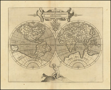
Rare set of 3 maps on a single sheet, including an imaginary view of the lands in Antarctica in the lower left.
The map at top is centered on Europe and does not include the western part of North America or the Pacific. It includes tables showing variations in longitude and latitude. The two maps below are polar projections. The Northern Hemisphere is an unusual chart with the continents of the Southern Hemisphere transposed over the map providing a visual depiction of the differences in landmasses. The map of the Southern Hemisphere shows the tracks of recent explorations and includes a "Plan et Vue des Terres du Cap de la Circoncision," an imaginary part of Antarctica.
A very unusual map. We have seen the separate maps offered for sale, but never the group on a single sheet.
Philippe Buache (1700-1773) was one of the most famous French geographers of the eighteenth century. Buache was married to the daughter of the eminent Guillaume Delisle and worked with his father-in-law, carrying on the business after Guillaume died. Buache gained the title geographe du roi in 1729 and was elected to the Academie des Sciences in the same year. Buache was a pioneering theoretical geographer, especially as regards contour lines and watersheds. He is best known for his works such as Considérations géographiques et physiques sur les découvertes nouvelles dans la grande mer (Paris, 1754).
![[World] Dated Events War Map . . .](https://storage.googleapis.com/raremaps/img/small/88833.jpg)