|
||

|

|
|

|
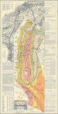
Interesting early map showing the road from Placerville to Carson City, published by the State Journal in Sacramento.
The map was drawn by George H. Baker, based upon a Survey done by William Henderson, the County Surveyor of El Dorado County. The map appeared in Report of Committee on Internal Improvements [on Assembly bill no. 16], published by B.B. Redding, the State Printer. The Report consisted of 20 pages and a printed map. The Beinecke annotation for the the map notes:
In the Library of Congress Copy is inserted, after the [title page] a folded map, 50 x 61 cm, with the title: "An improved topographical map of the northern & middle mines. Compiled from the most recent & authentic surveys, showing a practicable route for the great Atlantic & Pacific railroad, through the Sierra Nevada at Fredonyers Pass ... by M. Milleson, cl engineer. Published by lithd. by Alex. Zakreski ... 1854 San Francisco"; in lower margins, at left: "Entered according to Act of Congress ... 1854 by Alex. Zakreski ... "; at right: "Engraved by H. Steinegger"; below this, in manuscript: "Illustrative of exhibit C".
The copy in the Yale University Library, has inserted a map with title: "Map of wagon road route from Placerville to Carsonville. Drawn by George H. Baker from survey by Wm. Henderson, Co. Surveyor of Eldorado Co. State journal lith."
The Report in the collected set of California Assembly journal, 1855 Appendix, is without map. cf. A.R. Hasse, Index to econ. material in documents ... California, 1908, p. 7, no. 13, and p. 277.
The map illustrates on a mile by mile basis the road under construction to Carson City, along with neighboring towns and topographical features.
![California Water and Mining Co. [with:] Map of El Dorado County, Cal. Showing the Georgetown Divide and Portions of the Placerville and Forrest Hill Divide with the Ditches, Mines and Other Properties of the California Water Co. Situated Between The South Fork of Middle Fork and the South Fork of the American River 1880](https://storage.googleapis.com/raremaps/img/small/91927.jpg)
![[Berkeley] This Is The Map of Berkeley Town Its Streets Go Winding Up & Down An Oak-Covered Campus It Wears For A Crown With People & Places of Renown](https://storage.googleapis.com/raremaps/img/small/97201.jpg)