


|
||

|

|
|

|
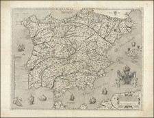
Striking full color example of Wagenhaer's map of the southwestern coast of Spain, including the Bay of Cadiz.
Includes a sea monster, 2 sailing ships, a compass rose, and 2 decorative cartouches, soundings, and anchorages. Profiles of the coastline are shown.
Wagenhaer was a Dutch pilot who produced the first set of effective navigational charts, under the title Spiegel der Zeevaerdt. These gorgeous charts, engraved by Baptist and Jan van Doetecum, embody the latest contemporary knowledge of navigation and position finding, and set the standard which was followed for more than a century. Waghenaer's charts are magnificent works of art, which are highly sought after by collectors. An essential map for collectors of the region and the earliest decorative sea chart of the region.
![[Penisola Castle / Valencian/Catalan Coast] Coste d'Espagne depuis Peniscola Jusqu'au Hamau du Canard ou Alcanario (hand drawn map)](https://storage.googleapis.com/raremaps/img/small/91695.jpg)