|
||

|

|
|

|
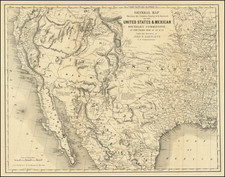
Unrecorded early promotional broadside route map and promotional text apparently published by the Red Bluff Independent (1860-1872), illustrating the routes from Red Bluff, California on the Upper Sacramento River to the gold diggings in Idaho Territory and promoting the various options for reaching the gold diggings.
The broadside is a treasure trove of early California and Northwestern personalities, including early Californian Job. F. Nye and Oregon-California emigrant Major Pierson B. Reading (both of whom participated in the Bear Flag Rebellion), whose decision to turn south for California at Fort Mill led to the establishment of the route to Red Bluff shown on the map. Of perhaps greatest import, the map is augmented with pencil annotations adding several historically important place names which were just then discovered, includinge Tim Goodale's Powder River Cutoff from the Boise Valley to the Powder River, "the Burnt River" Route, the "Auburn Oregon", "Mormon Diggings" and "Canon Creek," and other important early routes to the Idaho Diggings. These early annotations add critically important information to the printed data, which point to a printing date of late 1862 to early 1863.
While it is impossible to definitively connect these annotations, the confluence of facts correspond in location and theme with the ultimate "discovery" of one of the last great Ameican Treasure myths which grew up around the Oregon Trail, the so called "Lost Blue Bucket Mine." One of the last great "lost mine" tales of pioneer America, the Lost Blue Bucket Mine was perhaps the most enduring legends of the Pacific Northwest. "Discovered" by Oregon-bound emigrants in 1845, the gold-choked canyon was unquestionably one of the last El Dorado's of frontier America in the Lower 48 States.
The "Blue Bucket Country" was a rugged area of mountains, canyons, and volcanic plateaus in southeastern Oregon, northwestern Nevada, and southwestern Idaho. Bounded on the north by the John Day River, the Black Rock country of Nevada to the south, the rugged mountains near Silver City, Idaho a the east boundary and the Fort Rock Valley and the Lake region of south-central Oregon in the West, the region was more obstacle then opportunity for early settlers.
Like most of the great Western tales of lost gold mines, the Blue Bucket story has a number of varying accounts. The best suggest that the Lost Blue Bucket Mine was located in the Black Rock country of northwestern Nevada, on the Burnt River, Powder River, and the John Day River in Oregion, near the Malheur River, just west of Boise, and just east of the Lake country of south-central Oregon. While mythical in nature, a series of gold strikes swept the region starting in 1860, forever marrying fantasy and fact.
The presen map was prepared by Luicen Bonaparte Healy, then Country Surveyor of Tehama County, California, shortly after the discovery of Gold in Idaho Territory The map itself repesents a hastily created snapshot of the region, sufficient to provide a broadside advertisement to outfitters in Red Bluff, California, the point at which Californians bound for the newly discovered gold regions would have disembarked the steamship passage from the south and embarked on the difficult 400 mile trek to the gold mines.
While not formally organized recognized until March 1863, the independence of Idaho was being robustly debated in Washington and Washington DC as early as 1860, and with the explosion of the gold mining regions in Eastern Washington which first began in Florence in 1860, Idaho was well on its way to becoming formally recognized as a territory of the US. Ironically, Idaho was one of the original names considered for Colorado Territory, invented by George M. Willig (possibly as a joke) during the debate which created and named Colorado Territory.
Gold was first discovered in Idaho in the Clearwater River in 1860 and on the Salmon River in 1861. By 1862, word of the gold discoveries in the so-called Boise Basin on August 2, 1862, brought thousands of miners to the region. Situated about 24 miles north of Boise, Idaho, in the Pacific Northwest, USA, covering over 300 square miles, emigration to the basin in the 1860s made it the fastest growing community in the Northwest. It was one of the richest and most important discoveries of the gold rush days, and people moved to the area in droves. In "The History of Idaho," John Hailey writes that "many miners traveled from Portland, Oregon, boating up the Columbia River, then moving overland to the Snake River and on through the Payette River, finally reaching Horseshoe Bend and the Boise River Basin. The journey usually took about two weeks."
The discovery of gold also led to a massive emigration of Californians via the old California Trail back toward Idaho, and places such Boise, Old Fort Boise,, Owhyee and the new Idaho City (shown on this map), founded in October 7, 1862, quickly became boom towns. By December 1862, a major gold rush had commenced.
The routes from Red Bluff to the Gold regions boomed, with the traditional California Trail augmented by the construction of a private wagon road to Fort Boise via Owyhee and a second Wagon Road from Red Bluff through Susanville to the Humboldt River.
While this printed map focuses on the benefits of the routes from Red Bluff to Idaho, it is equally interesting for the pencil annotations on the map, reflecting early knowledge of pioneering routes utilized by early emigrants traveling from the Washington and the Columbia River, and for the cast of early Californians, whose knowledge is used as testimonial to the choice of routes.
While note mentioned by name, the influence of pioneer mountain manTim Goodale is clear. Goodale gained gold rush experience in California after a decade of western travel following his migration westward from Illinois in 1939. Before 1860, he had covered all of southern Idaho, and his reputation for geographical information exceeded that of nearly all professional guides. His association with Jim Bridger and Kit Carson enhanced his standing. As a result of his extensive travel in southwestern Idaho prior to 1862, Goodale was identified in an Idaho City newspaper (Idaho Times, published from September 11, 1866 to March 12, 1867) as an "old trapper of Snake river and its tributaries, who has, perhaps, covered every trail in what is now known as Boise, Alturas, and Owyhee counties. . . ."
When the Salmon River gold rush began, Goodale persuaded a large emigrant company to accompany him over an Idaho route from Fort Hall to Lost River, Wood River Valley, and Camas Prairie (with an ultimate destination of the diggings in Florence), an old fur route discovered by Donald Mackenzie in 1820. While the route had previously been tried by wagons in the early 1850s and deemed too difficult, Goodale believed the route would bypass Pocatello's Shoshoni band, which had destroyed a party near Massacre Rocks that chose not to accompany Goodale that season. Also, the grazing resources essential for oxen that hauled emigrant wagons had been ruined by two decades of Oregon Trail traffic, a problem that Goodale's cutoff avoided in many places. While his route did not reach the diggings, it would bring emigrants to within 20 miles of their goal. The success of Goodale's route would become known as Goodale's Cutoff.
Capitalizing on the cutoff, Goodale promoted an additional cutoff to Powder River, the scene in 1862 of a new rush that eclipsed Florence in importance. Regular Oregon Trail wagons west of Boise came by those new Powder River mines, but Goodale's people showed far more interest in Salmon River and Florence instead. So Goodale continued to take his customers as close to Florence as he could guide them. He started that phase of his 1862 cutoff by taking wagons from Eagle to Emmett by way of Freezeout Hill. On that part of his trip, he encountered what was left of George Grimes' Boise Basin discovery party. Grimes' new gold field proved far more valuable than Florence, and Goodale's cutoff would have served a more useful purpose by going there instead of trying to get closer to Florence. But unfortunately for Goodale's emigrants, that information was suppressed until late in 1862.
From Payette Valley on, Goodale faced new problems. Indian trails from later Emmett to Upper Weiser valley could not accommodate wagons, so Goodale was required to take his gold hunters down Payette valley to Snake River. To appease his clients who insisted upon going to Upper Weiser, he took them there. Other scouts connected with John Brownlee, needed help to get a wagon road opened to a Snake River ferry, in order to serve an old Indian trail that continued to Powder River. A free ferry service was offered if they would convert that trail into a wagon road from Upper Weiser valley (modern Cambridge). After they got there, they learned that they would have to build yet another wagon road so that they could get out of the Snake River's formidable canyon to Pine Creek.
Once they had entered Brownlee's trap they had to build his entire road to escape. After the party crossed to a less-obstructed trail over higher country near Pine Creek, where their route took them over the Powder River divide. Here they could follow a good natural road until they reached a rather steep grade down to a Lower Powder River valley. At this point, a somewhat circuitous route took them to a rim where they could descend to a satisfactory Powder River ford. Rising beyond that stream, their Indian trail wound through another series of natural barriers from which they finally emerged into relatively open country dissected by a number of streams that offered inconvenient but surmountable obstructions. But earlier wagons at least could ascend from Powder River to an Oregon Trail reunion below Flagstaff Hill. At that point, Goodale's emigrant crossed a relatively open valley for only a few miles to reach Auburn--a new mining camp for Oregon's Powder River placers.
Aside from not being their preferred destination at Florence, where they would have been too late to locate any fabulous claims anyway, Goodale's followers at least had reached some Oregon Trail mines. But they might have accomplished that a lot faster, and with a great deal less work, if they had simply gone west from Boise along their established emigrant road.
Ironically, an 1862 Boise Basin gold discovery by prospectors that Goodale's group had met on their westbound trip, transformed travel patterns in that area. Late in 1862, a gold rush to Boise Basin attracted a mining stampede to Goodale's route. Publicity for Brownlee ferry, made convincing because Goodale's wagon train had constructed a road that way, diverted many miners from other Oregon Trail alternates. Unencumbered by wagons, many of those who chose Goodale's cutoff could make a substantial saving by following a trail from Upper Weiser valley to Upper Payette valley. That route, which Goodale's wagons could not use, improved his cutoff greatly. So Brownlee's ferry flourished for a couple of years.
A second early route to the diggiings is reflected in the pencil annotation for the "Burnt River." Shortly after Tim Goodale's cutoff was extended from upper Weiser (around later Salubria and Cambridge) to John Brownlee's Snake River ferry in 1862, a gold rush to Boise Basin brought more traffic that way. Later in 1862, eager miners tried out a much more direct route to upper Payette valley than Goodale's road via lower Weiser and Payette. Old Indian trails via Crane Creek and upper Willow Creek gave them access to upper Payette valley a little north of Pickett's corral (a major early landmark close to Black Canyon) where they connected with another Payette gold rush route that came from Burnt River and Old's ferry. Both routes then proceeded up to Horseshoe Bend and Harris Creek to Placerville. When John Brownlee spent more time mining in Boise Basin than tending to his ferry, that route lost its popularity, and by late 1864, Brownlee's ferry was abandoned altogether. So his upper Weiser route to upper Payette valley also fell into disuse after less than two years service as a gold rush trail.
A second annotation noting "Auburn" is also of great importance. The mining town of Auburn, located in northeastern Oregon, eight miles southwest of Baker City, was established in about 1861, but consisted of no more than 1 or 2 structures until 1862.. Now deserted, Auburn was once the largest settlement in eastern Oregon and the center of a vibrant mining district on the southern edge of the Blue Mountains. A group of prospectors from the Willamette Valley first discovered gold in the area in October 1861, the first significant strike in eastern Oregon. By the spring of 1862, mining activity in the district had moved a few miles southward to the confluence of the Blue Canyon and Freezeout creeks.
By the fall of 1862, Auburn had grown into a fully developed town with general stores, saloons, lumber mills, blacksmith shops, butcher shops, hotels, and a school. In September of that year, the state legislature designated Auburn the first county seat of Baker County.. By 1863, the town had grown to an estimated 5,000 to 6,000 people, Auburn disappeared nearly as fast as it was established. By December 1864, the Salem Statesman reported that "the total number of residents would probably not exceed one hundred and fifty." Most of the miners had moved on to better diggings in Idaho.
The annotation noting Canon City is also of tremendous import. Located east of the John Day River, the discovery of gold in the region brought the first large influx of white men to Canyon City, Oregon. William Allred was a member of a party going to the gold mines in Idaho. His party travelled down Canyon Creek June 8 1862, then headed west at the present site of Canyon City. About midday they camped on Little Pine Creek not far from the site of the old town of Marysville. Allred decided to head back to Canyon Creek and do some prospecting, where he quickly located about four dollars worth of gold panning in the river.. Allred returned to camp, only to learn that his party had left him behind. He caught up to them in what is now the Prairie City country, but was unable to persuade them to return. By the time the party arrived in the Powder River country they'd heard several discouraging reports about the Idaho mines. They decided to head back and check out Allred's find.
They arrived back at Canyon Creek on July 3, 1862, to find a camp of several California miners hundred men who had staked out the creek bed down to the confluence with the John Day River and taken with claims. Within a year it is estimated there may have been 10,000 men in Canyon City, making it the largest city in the State of Oregon at that time. Concurrent strikes were than made at Prairie Diggin's, Dixie Creek near Prairie City, Elk Creek, Susanville and others on north toward Baker. In fact, the area between Canyon City and Baker was so rich in gold that it was known as the 'Golden Crescent'.
The last of the pencil annotations is for "Mormon Basin" and reflects perhaps the oldest of the Gold myths of the Pacific Northwest. The first official discovery of gold in what was to become "Blue Bucket Country" occurred in eastern Oregon during the summer of 1861. Rich placer deposits were discovered in Griffin Gulch, north of present-day Baker. At the same time, placer gold was discovered on Elk Creek and the middle fork of the John Day River. he 1860's saw rich strikes on Desolation Creek and the north fork of the John Day River and on Dixie Creek, southwest of Greenhorn. Other rich strikes followed including the Cornucopia, Sumpter, and Cracker Creek discoveries. These three districts collectively produced nearly a million ounces of gold.
On the eastern fringe of "Blue Bucket country", the first significant discovery of gold took place in 1863 in the Owyhee Mountains of southwestern Idaho. It was during that year that gold was discovered in the gravels of Jordan Creek. A mining camp called Silver City quickly sprang up around the rich diggings. Although the northern, eastern and southern margins of "Blue Bucket country" did yield rich mineral deposits, the interior was mostly barren. The exceptions are the Mormon Basin District, located 10 miles southeast of Bridgeport and the smaller Malheur District, located 10 miles to the southwest. The Mormon Basin District produced a respectable 235,000 ounces of gold while the Malheur District yielded about 10,000 ounces.
Red Bluff, California was settled by Peter Lassen,who obtained a 25,000 acre Mexican land grant in 1843, laid out a town in 1847, and initially recruited settlers from Missouri. Initially developed as Benton City (after Thomas Hart Benton), the first group of settlers arrived from Missouri in 1849, at exactly the time the Gold Discovery in California was first becoming widely publicized. The inducement of the Gold diggings resulted in most of the original settlers proceeding southward to the Gold Diggings. Despite Lassen's initial failure to develop Benton City, the neighboring Red Bluff town site's natural location at the upper navigable headwaters of the Sacramento, it was a natural point of commerce. By 1853, it was the chief marketing and distribution point in the northern part of of the Valley and the primary distribution point for commerce to and from Oregon, Idaho and Northern Nevada. The first daily steamship service arrived in Red Bluff as early as 1850.
Job F. Dye, who is noted as major contributor to the information on the broadside was one of California's more colorful early pioneers, would become a prominent merchant Silver City, Idaho Territory. Silver City is a ghost town in Owyhee County, Idaho. At its height in the 1880s, it was a gold and silver mining town with a population of around 2,500 and approximately 75 businesses.
Silver City was founded in 1864 soon after silver was discovered at nearby War Eagle Mountain. The settlement grew quickly and was soon considered one of the major cities in Idaho Territory. The first daily newspaper and telegraph office in Idaho Territory were established in Silver City.
Dye was born in Hardin county, Kentucky, in 1807. Dye emigrated to Arkansas then an unexplored wilderness, where he stayed until 1830. On a trip to New Orleans, he signed for a fur trip from Fort Smith to the Rocky Mountains. He immediately joined the expedition and left Fort Smith on in May, 1830. The experience began a long journey westward.
After several years and many experiences, Dye crossed the Rio Colorado, headed for the Pueblo de Los Angeles. Once in California, he travelled to the sea-coast of California to hunt and kill sea-otter, the skins of which were then worth from $25 to $45 each, in Los Angeles and in China, and $100 in the city of Mexico. He travelled to Santa Barbara, purchased a whale-boat and made a short trip up the coast, ultimately obtaining a pelt license from Don Roberto Pedro, which proved unsuccessful.
Dye next moved up the coast toward San Luis Obispo. After arriving at the mission of San Luis, he made a contract with Padre Luis Taquedo to hunt for the mission. The venture was successful, leaving Dye with funds to proceed to Monterey. The next fall Dye entered into a contract with Capt. John B. B. Cooper, of Monterey, to take 217 brood mares and convey them to a ranch on the coast, "Big Sur," and go into a general stock-raising business.
In 1835, Dye commenced the business of distillery, in Zayante Valley, near Santa Cruz,where he rented a portion of Don Joaquin Buelna's farm - called the "Zayante."
In 1840, Dye was briefly imprisoned during the Bear Flag Rebellion when he became involved in a scheme to kill all Mexicans in California, but was released 3 days later.
Unfortunately, Dye's good graces with the Mexican-Californio Government found him on the wrong end of things and his business was seized, leaving him in debt several thousand dollars to the various merchant vessels trading on the coast. He relocated to Monterey to begin business anew. At the same time, he obtained a land grant from the Government of Mexico, in what is now Tehama County. On this ranch he had about 1,000 head of horned cattle and 200 head of horses. At the time of the gold discovered by Sutter in Sacramento, Dye relocated to Tehama County and was immediately ready for adventure.
In the month of May, 1848, Dye launched a gold expedition. The party consisted of R. A. Thomas, A. G. Tooms, Dr. McKee, James Meadows and Job F. Dye, with two Indian boys to take care of camp. In visiting the Sacramento early, it was Dye's the intention to look after the ranches, rodeo stock, mark and brand the increase and attend to other interests in that section. On arrival at the ranch, it took about two weeks to secure the stock and commence mining activities. A small party headed for the mines. The proprietors of this new speculation was A. G. Tooms, R. H. Thoms, Grandville Swift, Mr. Gibson, Wm. Moon, James Meadows and Dye
The party brought forty-eight Indians and fifty head of beef cattle. The group proceeded to the Feather river and prospected and found gold sufficient to insure their belief that good mines existed on that stream. The first location made was named "Monterey Bar," afterwards changed to Long's Bar. Nye's group found the digging very rich. After forty-two day's work, the parties netted $70,000 after expenses.
Notwithstanding the richness of the diggings, Dye left, intending to visit Monterey. On arrival in Monterey, Nye met with General Riley, and gave a report of the mines, which he transmitted to Washington. This report created a great excitement over the world, and consequently a great rush was immediately made for California. Dye next chartered a small schooner, called the Mary, built in the Sandwich Islands, of 56 tons burden and proceeded to Mazatlan, where he purchased a cargo of merchandise, such as serapes, rebosas, and other Mexican manufactured goods, such as usually worn along the coast, he transmitted these northward to the Sacramento Valley, at which point his career as a merchant in the upper Sacremento region commenced.
The first newspaper established in the Boise basin was the Boise News, a small sheet owned and edited by T. J. & J. S. Butler, formerly of Red Bluff, Cal., where they published the Red Bluff Beacon, wich was in turn sold in 1862 to Charles Fisher, connected with the Sac. Union. Butler married a daughter of Job F. Dye of Antelope rancho, a pioneer of Cal, and went to farming in the Sacramento Valley. His father-in-law took a herd of beef cattle to the eastern Oregon mines in 1862, and sent for him to come up and help him dispose of them. Butler then started a packing business, running a train from Walla Walla to Boise, and recognizing that, with a public of 30,000 or more, there was a field for a newspaper, took steps to start one, by purchasing, with the assistance of Knapp of the Statesman office in Walla Walla, the old press on which the Oregonian was first printed, and which was taken to Walla Walla. Some other material was obtained at Portland, and the first number of the Boise News was issued Sept. 29, 1863, printing paper costing enormously, and a pine log covered with zinc being used as an imposing-stone, with other inventions to supply lacking material.
Pierson B. Reading came to California with Samuel J. Hensley as a member of the Chiles-Walker party in 1843. In 1844, Reading entered the service of General Sutter as a clerk, explorer, and chief of trappers, and commanded Sutters Fort in Sutter's absence. He received the 26,632 acres (108 km2) Mexican land grant Rancho Buena Ventura in 1844, the area occupied by today's Redding, California, and Cottonwood, California, along the Sacramento River. In 1846, Reading was a participant in the Bear Flag Revolt. In the Mexican-American War, Reading enlisted under Fremont and was appointed Paymaster of the California Battalion, with the rank of Major. In 1848 Reading was among the first to visit James W. Marshall's gold discovery in Coloma, California - and shortly after engaged extensively in prospecting for gold in Shasta County, at the head waters of the Trinity River. In the fall of 1849, Major Reading fitted out an expedition to discover the bay into which he supposed the Trinity and Klamath Rivers must empty. From 1849 to 1850, Reading operated a store in Sacramento with Samuel J. Hensley and Jacob R. Snyder. He was the Whig candidate for Governor of California in 1851.
In 1854, Reading went to Washington, D.C. for the US Supreme Court hearing on his land grant claim. There he met and married Fanny Wallace Washington. Reading returned his Rancho Buena Ventura in Shasta County in 1856, where he remained until his death. In 1864, Major Reading and K.V. Bumpass filed a claim at "Bumpass Hell." Reading also led the third recorded party to ascend Lassen Peak.
GOODALE'S CUTOFF FROM BOISE VALLEY TO POWDER RIVER; Number 1048 June 1994 and Number 1014, August 1993

![Southeastern Portion of California [San Diego, San Bernardino and Inyo Counties]](https://storage.googleapis.com/raremaps/img/small/83750.jpg)
![[Nevada and parts of California, Utah and Arizona] Explorations and Surveys South of Central Pacific R.R. . . . Preliminary Topographical Map Map Embracing in Skeleton a Portion Only of the Notes from Surveys . . . 1871 (with original text)](https://storage.googleapis.com/raremaps/img/small/82964.jpg)