|
||

|

|
|

|
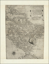
A highly decorative and important sea chart showing Florida, the Gulf Coast, Caribbean, Central America and the regiion from south of the mouth of the Delaware River.
This fine separately published map was first engraved around 1650, but is based closely on the work of Hessel Gerritsz and derived from Blaeu's West indische Paskaert, first published in 1630. However, the present map shows dramatic improvement over Blaeu's chart, most notably in the inclusion from an unknown source of the information around Delaware Bay.
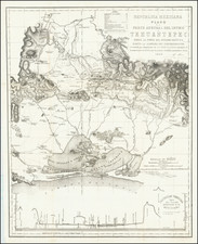
An important chart of this period showing the sea routes and explorations of the Spanish and Dutch during this period. This chart of the West Indies by Jacobsz Theunis was published in a Dutch composite sea atlas mainly with charts by Pieter Goos, who was 'one of the best known maritime booksellers of Amsterdam' (Koeman), he published a number of different sea-atlases or pilot books, his work was very much derivative. With his 'Zee-Atlas' he relied heavily on Hendrick Doncker's 'Zee-Atlas' of 1659. The map is known in only one edition and is very rare, this being only the 2nd example we have seen in 25 years.