The item illustrated and described below is sold, but we
have another example in stock. To view the example which
is currently being offered for sale, click the
"View Details" button below.


|
||

|

|
|

|
Stock# 20704
Description
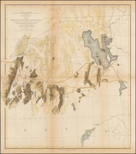
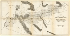
Scarce regional map of the region,
The map was prepared by the Citizens Executive Committee on a proposed reservoir and irrigation of Yuma County, in August, 1889. Terrific detail along the Gila River including surveyed townships and topography. Lines show the limits of irrgated lands at different water levels in the proposed reservoir. A rare and fascinating piece of Arizona history.
Condition Description
Minor loss at folds