|
||

|

|
|

|
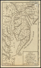
Rare first edition of Morden's map of the Carolina, offered here in the significantly revised second state. One of the earliest obtainable English maps of the Carolinas.
Beginning in the 1670s, the English fortunes in North America took a dramatic turn upward, resulting in a booming interest in the British American Colonies and, in turn, the issuance of maps to satisfy this interest. This map of the Carolinas first appeared in the 1680 edition of Morden's Geography Rectified with the title Carolina, Virginia, Maryland & New Jersey. A second state of the map, with a revised title (this map), was issued in Richard Blome's The Present State of His Majesty's Isles and Territories in America, published in 1687. Beginning in 1688, Morden issued a revised set of maps, with the Carolinas map changed to a reduced version of Thornton, Morden & Lea's A New Map of Carolina.
While the map extends to New Jersey, the focal point of the map is the Carolinas, as the latitude north of Cape Henry is compressed. The map is derived from Morden & Berry's New Map of the English Plantations in North America, in 1673, with the exception of the addition of Barkely County, near Charles Town. In the second edition, there are additional revisions to the map, including the re-engraving of the Cooper River (starting further west than the first edition), and the addition of the Stone and Edisto Rivers (replacing Lock Island and R. Grande).
North of Charles Town, the old Charles Town is erroneously added, as are Watere R and Sante R. This erroneous depiction is likely drawn from Joel Gascoyne's map of 1682. Farther south, Edelano Island is formed at the outlet of a branch of Ashley Lake, with St. Catalina being named farther offshore.
Robert Morden (d. 1703) was a British map and globe maker. Little is known about his early life, although he was most likely apprenticed to Joseph Moxon. By 1671, Morden was working from the sign of the Atlas on Cornhill, the same address out of which Moxon had previously worked. Most famous for his English county maps, his geography texts, and his wall maps, Morden entered into many partnerships during his career, usually to finance larger publishing projects.