This item has been sold, but you can enter your email address to be notified if another example becomes available.


|
||

|

|
|

|
Stock# 19980
Description
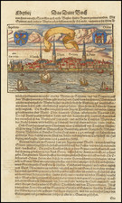
Rare English edition of Waghenaer's map of the Island of Oesel, Straits of Riga and parts of the Baltic Coast.
Includes sea monsters, sailing ships, compass rose, decorative cartouche, soundings, anchorages and soundings. Wagenhaer was a Dutch pilot who produced the first set of effective navigational charts, under the title Spiegel der Zeevaerdt.
These gorgeous charts, engraved by Baptist and Jan van Doetecum, embody the latest contemporary knowledge of navigation and position finding and set the standard which was followed for more than a century. Waghenaer's charts are magnificent works of art, which are highly sought after by collectors. An essential map for collectors of the region and the earliest decorative sea chart of the region.
![[Helsinki and Talinn] De Zeecusten van Lijflandt van Dageroort tot Revel en van Vinlandt daer tegen over](https://storage.googleapis.com/raremaps/img/small/75573.jpg)