|
||

|

|
|

|
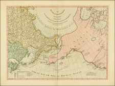
Highly detailed map of the southern portion of Queen Charlotte's Island and the continguous coastline of British Columbia, in the area of Canal de Grenville and Hawkesbury.
Detailed and interesting map. From Vandermaelen's remarkable 6 volume atlas, which if combined as globe gores forms an immense globe. Vandermaelen accomplished the first atlas mapping of the world on a uniform scale.
Philippe Marie Vandermaelen (1795-1869) was a Belgian cartographer and geographer known for his pioneering use of technology and his leadership in establishing the important Establissement geographique de Bruxelles. Born in Brussels, Philippe was obsessed with maps from a young age. He taught himself mathematics, astronomy, and mapmaking and plotted the battles of the Napoleonic wars avidly. He took over his father’s soapmaking business briefly in 1816, but then turned it over to his brother in favor of cartography.
From 1825 to 1827, he released his first atlas, the Atlas universal, which was well received. It was sold in forty installments of ten maps each, with 810 subscribers listed. The atlas contained 387 maps in six volumes at a uniform scale of 1:1.6 million. The maps were intended to be joined and together would create a globe 7.755 meters wide. It was the first atlas to show the entire world on a large uniform scale and was the first atlas produced using lithography. This project served as Vandermaelen’s gateway into intellectual life, gaining him membership in the Royal Academy of Sciences and Belles-Lettres of Brussels (1829).
In 1830, Vandermaelen inherited a laundry from his parents which he converted into the Establissement geographique de Bruxelles, or the Brussels Geographical Establishment. His brother, Jean-Francois, also established a botanical garden on the site. The Establishment had its own lithographic press, one of the first to use the technology for cartography and the first in Belgium. They produced textbooks, surveys, and especially maps of Brussels to be used for urban planning. The complex also housed schools, an ethnographic museum, and a library open to the public. Vandermaelen was passionate about geographic education and saw the Establishment as an open place where people could learn about the world.
In 1836, he was knighted for his services to geography and the intellectual community of Belgium. He died at age 73 in Molenbeek-Saint-Jean, near the Geographical Establishment that he founded. After Vandermaelen’s death, the Geographical Establishment declined, closing its doors in 1880. The extraordinary collection they had amassed passed to several institutions, most importantly the Royal Library of Belgium.
![[Alaska] Das Russische Amerika.](https://storage.googleapis.com/raremaps/img/small/95557.jpg)